Sometimes you need to see the bigger picture to understand the scale of a problem. A new visualisation from the Copernicus programme in Europe has done exactly that, showing how wildfires have been worsening around the world.
Sometimes you need to see the bigger picture to understand the scale of a problem. A new visualisation from the Copernicus programme in Europe has done exactly that, showing how wildfires have been worsening around the world.
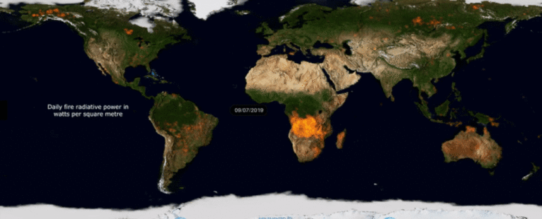
Pulling together imagery and sensor readings from satellites, the 92-second clip shows our world on fire during 2019, mapping the areas of the planet that lit up with wildfires over the course of the last 12 months.
As the clip develops, the seriousness of the problem becomes clear: some parts of the world barely get a break from wildfire activity during 2019. Other regions light up, then go dark again as the seasons change.
https://www.youtube.com/watch?v=9rsqpR0aGvYVIDEO
The data were pulled together and made available through an initiative called the Copernicus Atmosphere Monitoring Service (CAMS). It’s organised by the European Centre for Medium-Range Weather Forecasts, and is designed to help governments and companies plan for wildfires and the resulting pollution.
"It has been an extremely busy year for CAMS regarding the monitoring of wildfires," says CAMS senior scientist Mark Parrington. "Throughout the year we have been closely watching the intensity of the fires and the smoke they emit all around the world and have experienced at times some quite exceptional fire activity.
"Even in places where we would expect to see fires at certain points of the year some of the activity has been surprising."
…

