It’s been said that a rug can really tie a room together. In a similar fashion, Manoochehr Shirzaei and his research team are hoping that weaving together millions of data points into terrain-covering, digital maps can help connect the realities of sinking landscapes to the overall impact of climate change.
“It’s like a carpet over the desert,” Shirzaei, associate professor of radar remote sensing engineering and environmental security, said of a recent projection of land in Arizona. “You can clearly see that area is just massively sinking into the ground. And we’ve created these maps for dozens of major cities in the United States and monitor another 50 airports globally.”
Using publicly available satellite imagery, Shirzaei and the 15 student and postdoctoral researchers at Virginia Tech’s Earth Observation and Innovation Lab measure millions of occurrences of sinking land, known as land subsidence, spanning multiple years. They then create some of the world’s first high-resolution depictions of the land subsidence, which when combined with other observations, such as sea-level rise, provide more clear projection of the potential impact of floods and natural disasters during the next 100 years.
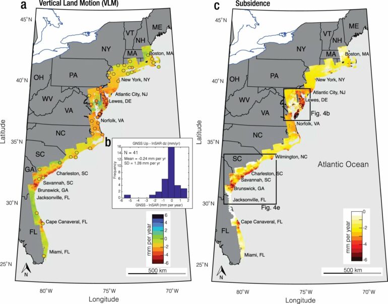
Most recently, the lab’s mapping served as the foundation for graduate student Leonard Ohenhen’s findings published in Nature Communications. Using satellite-obtained data from 2007-21, Ohenhen mapped the entire East Coast to demonstrate how the inclusion of land subsidence reveals many areas to be more vulnerable to floods and erosion than previously thought.
“We saw places like New York City and Charleston [South Carolina] are sinking up to as much as two millimeters per year,” said Ohenhen, one of the lab’s graduate students. “It really shows the hidden vulnerability of the Atlantic East Coast to sea-level rise.”
The unique, high-resolution maps crafted in the Earth Observation and Innovation Lab also have drawn the attention of multiple government agencies. This has led to the investment of millions of external dollars in an effort fill a critical gap of information and help people better plan at the local, state, federal, and global level.
“One of the big uncertainties we have is how the land is moving up or down through time, so we’ve turned to Manoo,” said Patrick Barnard, a research geologist with the United States Geologic Service (USGS). “This information is needed, no one else is providing it, and Manoo’s stepped into that niche with his technical expertise and is providing something extremely valuable.”
Land movement can be the result of natural processes, such as tectonics, glacial isostatic adjustment, sediment loading, and soil compaction, but can also result from human behaviors, such as extracting groundwater and gas and oil production.
Barnard said the vertical land motion rates provided have helped the USGS produce better models and give better guidance to other agencies in terms of managing and mitigating the risk of flooding. This impacts everything from real estate values and building plans to hurricane evacuation routes and the location of future levees.
The Earth Observation and Innovation Lab played a key role in recent USGS projections of future hazards on the Atlantic coast. The project consists of several data sets that map future coastal flooding and erosion hazards due to sea level rise and storms for Florida, Georgia, and Virginia with a range of plausible scenarios through 2100.
“Having this collaboration helps us refine the risk to lives and dollars communities face from sea level rise and storms,” Barnard said. “This is a really valuable data set they provide.”
Bringing such realities into focus for the average person is at the heart of Shirzaei’s efforts and the work of the lab.
“We’re creating access to actionable data that will help people become resilient when it comes to national and environmental security,” Shirzaei said. “The data we’re providing, we’re making it more than just open access, we’re making it usable by everybody. You don’t have to have a Ph.D. to use it. That’s our niche here.”
Along with flood projections for the entire East Coast, part of the paper published in Nature Communications highlights the vulnerability of the wetlands, which often provide a barrier between floods and people by absorbing flood waters slowly. Ohenhen said he hopes his research makes clear that ecosystem’s importance to the residents of those areas.

“Protect the wetlands is the overall message to the average person,” Ohenhen said. “Most people, they try to protect just enough of their property and leave other areas like the wetlands to basically fend for own survival. But when we do that, we’re really just creating a greater threat for ourselves.”
Shirzaei said he hopes the maps created for Ohenhen’s paper are used by policymakers and leaders to prevent areas from remaining undefended from flood waters. Similarly, he hopes the Earth Observation and Innovation Lab as a whole continues to be utilized in ways that help people better understand and prepare for potential risks.
“At the moment, the problem a lot of people have is they don’t know the hazard that might come in the future,” Shirzaei said. “Our data will help them understand that and come up with better plans for the future.”
More information:
Leonard O. Ohenhen et al, Hidden vulnerability of US Atlantic coast to sea-level rise due to vertical land motion, Nature Communications (2023). DOI: 10.1038/s41467-023-37853-7
Citation:
Critical observations reveal sinking coasts (2023, April 12)

