A first count of trees in Africa’s drylands has enabled scientists to calculate how much carbon they store and could help devise better conservation strategies for the region and beyond, a study said Wednesday.
The number of trees in the vast region—the count came to nearly 10 billion—has not been known up to now, and the new data could prove crucial for slowing or preventing desertification, the authors said.
“(It) tells us about the carbon cycle and how much carbon we have in trees is mitigating climate change and our abuse of fossil fuels,” Compton Tucker, co-lead author of the study published in the journal Nature, told AFP.
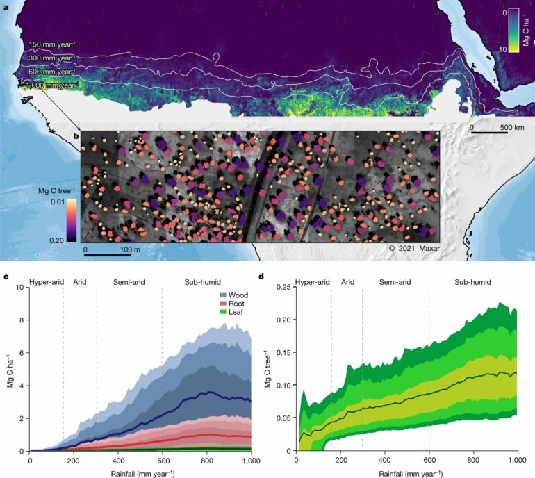
Dryland trees capture carbon for much longer than grasses and other non-woody species in the region, even if individually they do not store huge amounts.
The data show there are 9.9 billion trees within Africa’s drylands: semi-arid Sub-Saharan Africa north of the Equator, which includes the Sahel and covers nearly 10 million square kilometres (four million square miles) of land from the Atlantic Ocean to the Red Sea.
That’s the size of continental United States, plus Alaska, said Tucker, a senior Earth scientist at NASA.
By comparison, there are an estimated 400 billion trees in the Amazon.
Without accurate data on the number of trees in the Sahel, previous estimates largely overestimated the region’s carbon-storage capacity, the study said.
The data could also help inform policies such as the Great Green Wall Initiative, which aims to restore savanna, grasslands and farmlands across the Sahel.
Policymakers, experts and donors can better track tree coverage—and deforestation—in the region, and understand how trees are being used by local communities.
“There is a lot of money in green finance dedicated to avoiding deforestation that has not been used due to a lack of reliable verification systems,” said contributing author Philippe Ciais.
“High-resolution spatial data is crucial to improving the quality of carbon credits.”
Interactive map
The researchers used machine learning to scan more than 300,000 high-resolution satellite images to map the crown area of individual trees in the drylands, defined as an arid region with low rainfall.
The authors hope to improve on the tool in the future by being able to map the trunk of the tree to determine its age and height, allowing for more accurate data on carbon storage capacity.
“When you want to estimate wood mass, it would be much better if—in addition to the crown cover—we had the height,” co-lead author Pierre Hiernaux told AFP.
“It’s almost possible but not yet.”
Tucker said the same methodology could be used in other drylands including in Australia, the western United States or Central Asia.
An interactive map showing the location of individual trees and details the amount of carbon they store is available online.
Tucker hopes the data won’t be used for harmful intentions.
“Any time you do something like this, you can certainly be used for bad purposes. We hope it’s used for good.”
The interactive map is available at: trees.pgc.umn.edu/app
2023 AFP
Citation:
Tree count in Africa drylands could improve conservation: study (2023, March 1)

