Hurricane Ian strengthened as it headed for Florida and was on track to bring a powerful storm surge and potentially flooding rainfall to most of the state this week.
After a slow start to the 2022 Atlantic hurricane season, Ian has ideal conditions. It faces minimal vertical wind shear – the difference in wind speeds and directions at different heights that can tear apart a storm. And the Caribbean Sea and Gulf surface waters are warm, providing fuel for the storm.
Forecasters expect Ian to become a major hurricane – Category 3 or higher on the Saffir-Simpson Hurricane Wind Scale, meaning winds over 110 mph – likely before crossing western Cuba on Tuesday. Its winds could weaken before landfall in the U.S., but the scale doesn’t take water risk into account, and flooding and storm surge are both major risks from Ian.
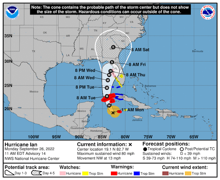
Ian’s forecast as of Monday, Sept. 26, 2022. The probable path may shift as the storm moves through the Gulf of Mexico.
National Hurricane Center
As a meteorologist living in Florida, I study tropical storms and hurricanes. Here are three reasons Florida’s Gulf Coast is facing a high risk of water hazards this week.
The rainy side of the storm
Tropical systems are not perfectly symmetrical systems – one side is typically larger. With Ian tracking up the west coast of Florida, the peninsula is expected to be on the “wet” side of the storm. The part of the storm east of the center of circulation generally has more cloud cover and more rain.
The most dangerous side of the storm is its upper right quadrant.
While Ian travels up the Florida coast, these outer bands will stretch over much of the peninsula and produce heavy rain for many locations, beginning as early as Monday night for South Florida and late Wednesday for northern parts of the state.
Some weather models are forecasting 10 inches or more of rain in the region where the storm makes landfall, possibly as high as 15 inches, while other regions could see 4 inches or more.
Regardless of the landfall location, most of the Florida Peninsula will see effects from Hurricane Ian.

Storm surge risk
As Hurricane Ian continues to track north, it will be pushing the waters of the Gulf of Mexico northward with it. This is storm surge, and it raises the water level, with waves on top adding to its destructive power.
The Gulf acts like a huge bathtub, and when strong storms enter into this region, they help lift up the water due to low barometric pressure. Barometric pressure has a direct influence on sea levels. When air pressure rises, sea levels lower. However, lower barometric pressure lifts the sea.
Additionally, the storm’s strong winds will push the water in the same direction the storm is heading. Since land surrounds the Gulf of Mexico, there is nowhere for this water to go but inland.