Preparations for a safe landing on Earth, such as finding the most even terrain and equipping the appropriate landing gear, are also crucial for Mars missions.
Thus, landing a rover on Mars requires careful mapping and planning well before a rover’s descent begins. Scientists are working to create accurate 3D surface maps, known as digital terrain models, of the planet by compiling mosaics of images from past missions.
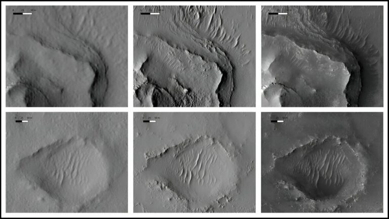
Progress in image processing technologies over the past two decades has advanced map resolutions from hundreds-of-meter to submeter scales. Although this is an extraordinary improvement, even resolutions of 1 meter per pixel cannot fully capture fine-scale features like dune textures, small craters, and large rocks.
To better map these geologic features around the 2020 Perseverance landing site at Jezero crater, Yu Tao and colleagues use a deep learning model called Multi-scale Generative Adversarial U-Net (MADNet), which they designed in previous work. The new research is published in the journal Earth and Space Science.
MADNet, trained using a blend of existing, postprocessed digital terrain models with resolutions ranging from 4 to 36 meters per pixel, refined the publicly available Mars 2020 Terrain Relative Navigation High Resolution Imaging Science Experiment (HiRISE) digital terrain model mosaic. The researchers also checked and refined multiple iterations to eliminate artifacts and gaps in the outputs.
The result is the 50-centimeter-per-pixel MADNet HiRISE Jezero digital terrain model mosaic. Compared with the original mosaics, the MADNet maps have an average height difference of just 0.009 meters, with a 0.63-meter standard deviation, indicating that the results of the deep learning approach align with the traditional photogrammetric approach.
The researchers note that their product shows significant improvements over existing maps, including (1) increased effective resolutions that show fine-scale surface features like dunes, craters, and rocks; (2) reduced striping artifacts; (3) the elimination of regions with low matching qualities; and (4) the elimination of interpolation artifacts. Their results are publicly available.
More information:
Yu Tao et al, A High‐Resolution Digital Terrain Model Mosaic of the Mars 2020 Perseverance Rover Landing Site at Jezero Crater, Earth and Space Science (2023). DOI: 10.1029/2023EA003045

Provided by
American Geophysical Union
This story is republished courtesy of Eos, hosted by the American Geophysical Union. Read the original story here.
Citation:
Mapping Mars: Deep learning could help identify Jezero Crater landing site (2023, December 4)

