
Scientists often field check their findings, heading outside to see if computer models match with what is happening in the real world. But doing so is challenging when the field is two and a half miles up. Enter a new field assistant: The great frigatebird.
Great frigatebirds live in tropical regions and routinely fly to 2,000 meters (1.25 miles) in altitude, occasionally reaching heights of 4,000 meters (2.5 miles). A new study shows that great frigatebirds equipped with tiny sensors can give detailed information about the planetary boundary layer (PBL), which is the dynamic atmospheric layer that is closest to Earth and where we experience weather, air quality, and climate impacts.
The new research was presented at the AGU Annual Meeting on Wednesday, 13 December in San Francisco and online.
The PBL connects the atmosphere with the surface ocean, land and ice. It rises and falls throughout the day and “many weather and climate processes are related to that fluctuation,” said Ian Brosnan, a marine scientist at NASA’s Ames Research Center who led the work. “So understanding PBL dynamics is fundamental to answering a lot of questions about the Earth system.”
Current techniques typically rely on ground-based measurements or remote sensing, but for far-flung regions over the oceans, “getting in situ samples of any sort at scale is a challenge,” Brosnan said.
Brosnan’s co-author, NASA ecologist Morgan Gilmour, previously used sensor-laden great frigatebirds to assess whether the boundaries of a marine protected area around Palmyra Atoll in the Pacific Ocean protected the animals within it. Brosnan suspected the frigatebirds’ flights were related to the PBL; if so, Gilmore’s project had also collected critical PBL samples.
“I instantly thought the birds could be traveling to the top of the PBL, turning around, and coming back down,” Brosnan said. “And they’re probably covering a pretty broad area, too.”
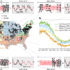
To check if the birds’ flight patterns matched PBL altitudes, they compared PBL measurements from 2006–2019 analysis to frigatebirds’ flights.
They found that the long-term average PBL heights in that area very closely matched the bird’s altitude data. Brosnan’s hunch was right.
The tagged frigatebirds had sampled temperature profiles in the PBL and had no trouble collecting data during cloudy weather or at night, unlike traditional sampling approaches.
“These novel approaches to using animal tracking data can help NASA measure the planetary boundary layer and improve climate predictions and weather and air quality forecasts,” Brosnan said.
He mentioned that after hearing from interagency scientists about how important global, satellite-based animal tracking data was for their research projects, NASA created the “Internet of Animals” project. This allows scientists to integrate data from remote sensing measurements with data from sensors on animals, now including the great frigatebird PBL data.
Brosnan said their work is a good example of how interagency and interdisciplinary collaborations can help tackle larger science questions. “One of the things we’re trying to do is bridge between these two communities—animal tracking and atmospheric science—and see if we can enrich the work that we both do.”
More information:
Can tagged great frigatebirds (Fregata minor) be used to track the dynamics of the planetary boundary layer height? agu.confex.com/agu/fm23/meetin … pp.cgi/Paper/1321690
Provided by
American Geophysical Union
Citation:
Great frigatebirds wearing backpacks map the atmosphere (2023, December 13)

