Parker VanValkenburgh has dedicated more than a decade of research to understanding how colonialism impacted Peru’s Indigenous people in the 16th century. That time marked a turning point in the region: Spanish forces conquered the Inca Empire, initiating a period of social violence and upheaval that included the forced resettlement of more than 2 million Indigenous people into a series of planned towns.
In the past, VanValkenburgh, an associate professor of anthropology at Brown University, led intensive archaeological survey and excavation projects to study the effects of these transformations on Indigenous peoples’ daily lives. He’d spend years focused on just one valley or site, studying post-colonization dietary changes by excavating pits filled with food waste.
VanValkenburgh believed that work was valuable, but he longed to zoom out—to see how his findings fit into, or differed from, other scientists’ findings across the region. So he partnered with Steven Wernke, an associate professor of anthropology at Vanderbilt University, to develop a tool that would map cultural and environmental change at a much larger scale.
The result is the Geospatial Platform for Andean Culture, History and Archaeology, or GeoPACHA—an open-source, browser-based platform that allows teams of researchers to work together to map archaeological sites in high-resolution satellite imagery.
“Archaeologists are really good at the small picture,” VanValkenburgh said. “We can dig into pits and tell you the minuscule ways in which the soil changed over time. But we lack the kinds of systematic data that we need to make sweeping statements about how those changes fit into the bigger picture of the growth of Indigenous societies in the past, of the Inca Empire’s rise and fall, and of the large-scale effects of Spanish colonization.”
In collaboration with colleagues across the United States, Peru and several other countries, VanValkenburgh, Wernke and colleagues spent a year using GeoPACHA to gather data on ancient sites, roads, livestock corrals and agricultural terraces. Their work has yielded a raft of new findings about how Spanish colonization and forced resettlement changed the region’s population density, its natural landscape and in some cases even its climate.
The findings, detailed across six new papers, were published online in Antiquity. They also feature in the journal’s February 2024 print edition.
VanValkenburgh explained that the GeoPACHA project is important because it does more than elucidate sweeping 16th-century changes in the Andean region. It also shows that, when archaeologists who study niche topics work together to collect multiple points of data, they can identify important historical shifts in climate and culture across the globe.
“Working at larger scales can help archaeologists generate more impactful research that addresses topics like the development of social inequality, the devastating legacies of colonialism and the responses of past societies to climate change,” VanValkenburgh said. “We need a deeper record of how humans have dealt with these sorts of challenges in the past. Archaeology is one of the rare fields that provides us with the kind of time depth we need to do that.”
Mapping history
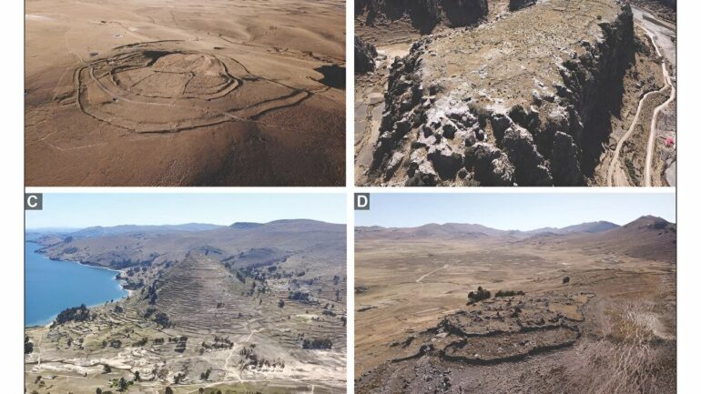
GeoPACHA began in 2018, when VanValkenburgh and Wernke brought together a handful of researchers who aimed to answer specific archaeological questions using large-scale satellite mapping. One team, for example, was focused on mapping hilltop fortifications to answer questions about social conflict in the Andes between 1100 and 1400. Another hoped to identify sites associated with lomas—verdant, fog-shrouded oases dotted throughout an otherwise arid landscape—to identify patterns in where Indigenous people chose to settle.
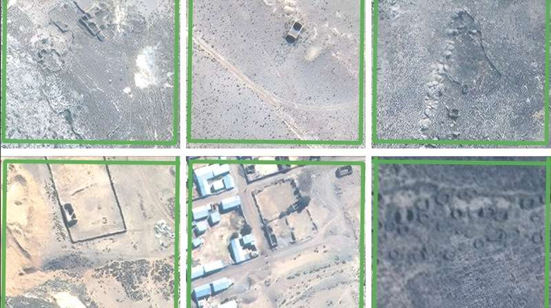
Working with high-resolution satellite imagery in GeoPACHA, the researchers used their specialized knowledge to find and tag certain landmarks, including hill forts and sheep corrals.

To expand the project’s scope, GeoPACHA researchers are training AI to recognize certain archaeological sites by feeding it thousands of images like these. © GeoPACHA researcher James Zimmer-Dauphinee
“It’s what we’d call ‘brute-force’ surveying,” VanValkenburgh said. “You take people who are trained to recognize archaeological sites, and you have them just click whenever they recognize something.”
After the mapping work came months of analysis, much of which is detailed in the new Antiquity publications. Some of the scholars’ analyses identified patterns that have yielded important new insights into how life changed in the Andes after Spanish colonization.
Bethany Whitlock, a recent Brown Ph.D. graduate in anthropology, led one study analyzing the locations of roads and sheep corrals in Peru’s central highlands. Whitlock said she discovered that herding infrastructure tended to be “concentrated around important colonial and present-day settlements”—evidence, she believes, of the long-term impact of colonialism on pastoralism and settlement in the Andes.
Giancarlo Marcone, a professor at Peru’s Universidad de Ingeniería y Tecnología, led another study analyzing lomas on Peru’s central coast. Marcone said there’s evidence that past settlers spent significant time in these pockets of dense vegetation, but their activity isn’t well documented because scientists can’t access the lomas’ remote locations on foot. With GeoPACHA, he said, it’s finally possible to begin studying how changes to culture and climate have transformed lomas.
“These research efforts are an urgent priority for understanding the long-term history of this part of Andean South America,” Marcone said.
GeoPACHA’s next phase
VanValkenburgh, Wernke and other colleagues’ archaeological mapping work doesn’t end here. Along with Vanderbilt Assistant Professor of Computer Science Yuankai Huo, the pair plan to broaden the project’s scope, this time with the assistance of artificial intelligence. Using deep learning methods, the GeoPACHA team will be able to survey nearly all of the central Andean region.
VanValkenburgh said the second phase of the project will pull in additional scholars from Peru, Chile, Bolivia and Ecuador, countries that include lands that were once part of the vast Inca Empire. Those scientists will evaluate the data collected by AI and enrich it with their own specialized knowledge.
“We’re taking those data that were painstakingly curated during the first phase of the project, and we’re using them to train deep learning models to identify sites en masse,” he said. “Using AI, we’ll be able to cover an area that’s 10 to 20 times larger than our initial research areas. The questions we can address with such a large data pool are pretty exciting.”
Data from the three-year project could beget years of analyses and new archaeological findings, VanValkenburgh said. Locating and dating every single ancient terrace ever built in the Andes, for example, could help archaeologists answer important questions about how climate change, population density and imperial expansion influenced Indigenous people’s decisions about where to settle and grow crops.
Questions like those, he said, seemed impossible to answer back when he was excavating individual pits in one small valley. While the excavation of interesting individual items can be exciting for archaeologists and the general public, he said, so can large-scale, multi-country digital projects like GeoPACHA.
“There’s this myth that archaeology is about stuff: Lost city discovered! Ancient scrolls found!” VanValkenburgh said.
“Individual discoveries do matter, but fundamentally, archaeology is about relationships—it’s about understanding how people interacted with each other, how different societies on different continents were similar and different, how the past connects with the present. That can happen when we venture beyond our individual sites and build our own relationships across institutions and borders.”
More information:
Steven A. Wernke et al, Large-scale, collaborative imagery survey in archaeology: the Geospatial Platform for Andean Culture, History and Archaeology (GeoPACHA), Antiquity (2023). DOI: 10.15184/aqy.2023.177
Elizabeth Arkush et al, A new view of hillforts in the Andes: expanding coverage with systematic imagery survey, Antiquity (2023). DOI: 10.15184/aqy.2023.178
Giancarlo Marcone et al, Late pre-Hispanic fog oasis settlements and long-term human occupation on the Peruvian central coast from satellite imagery, Antiquity (2023). DOI: 10.15184/aqy.2023.179
Giles Spence Morrow et al, Augmenting field data with archaeological imagery survey: mapping hilltop fortifications on the north coast of Peru, Antiquity (2023). DOI: 10.15184/aqy.2023.176
Bethany Whitlock et al, Managing pastoral landscapes: remote survey of herding infrastructure in Huancavelica, Peru, Antiquity (2023). DOI: 10.15184/aqy.2023.174
James Zimmer-Dauphinee et al, Eyes of the machine: AI-assisted satellite archaeological survey in the Andes, Antiquity (2023). DOI: 10.15184/aqy.2023.175
Citation:
Anthropologist’s mapping project shows how Peru transformed after colonization (2023, December 19)


