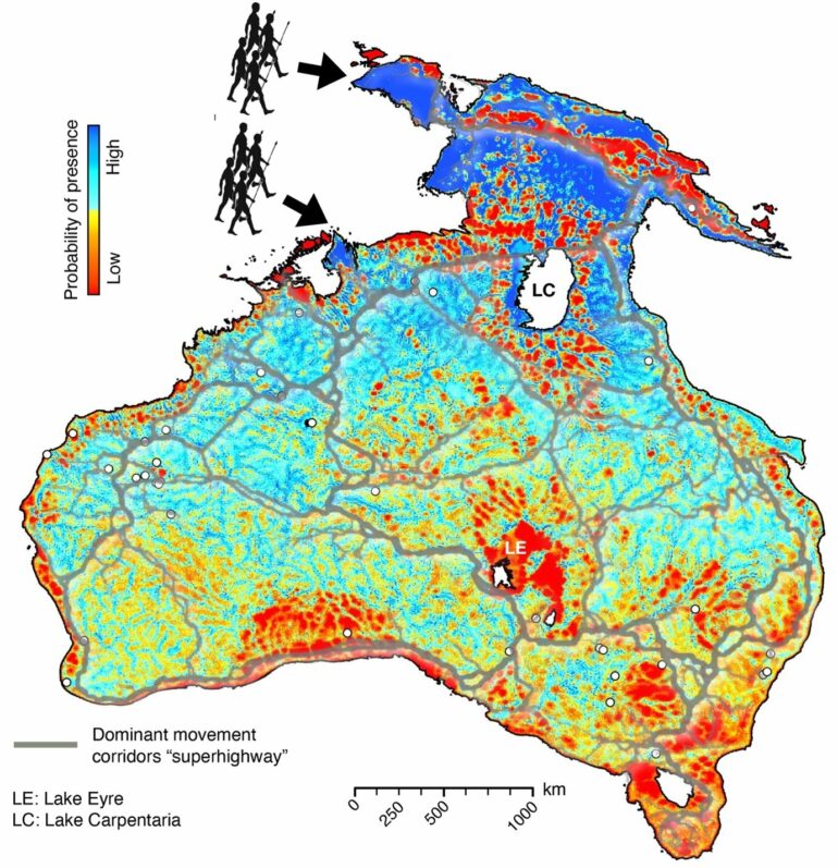
New research led by the University of Sydney offers fresh understanding of the migration patterns of Australia and New Guinea’s First Peoples, and where they lived in the 40,000 years following humanity’s arrival on the then combined continent. The work is published in the journal Nature Communications.
Using a dynamic model charting the changing landscape, researchers have provided a more realistic description of the of the areas inhabited by the first humans to traverse Sahul: the landmass combining what is now Australia, Tasmania and New Guinea.
Led by Associate Professor Tristan Salles from the School of Geosciences at the University of Sydney, the research model factors-in evolution of the landscape, driven by climate, during the time of human dispersal. This is a novel approach; previous studies of migration patterns have relied heavily on archaeological findings.
“One aspect overlooked when evaluating how people spread across the continent is the evolution of the Earth’s surface which took place as people migrated,” Associate Professor Salles said.
“Yet landscapes and landform are deeply engraved in Aboriginal culture.”
Humans first set foot on Sahul around 75,000 years ago. The research team used an established landscape evolution model detailing climatic evolution from 75,000 to 35,000 years ago. The model offers a fresh perspective on terrains and environments inhabited by the first hunter-gatherer communities as they traversed Sahul.
Researchers ran thousands of simulations to describe possible migration routes originating from two entry points into Sahul: a northern route through Western Papua and a southern route from the Timor Sea shelf.
Their results were consistent with previous findings, predicting a high likelihood of human occupation at already iconic archaeological sites, such as Ngarrabullgan Cave (in North Queensland), the Puritjarra rock shelter (Central Australia), and the Riwi Cave and Carpenter’s Gap 1 rock shelter in the Kimberley (Western Australia).
Results indicated migration speeds of between 360 meters and 1.15 kilometers a year, depending on entry points and arrival times. They also show that human settlers would have dispersed across the continental interior along river corridors on both sides of Lake Carpenteria.
“Our palaeoecological reconstructions show evidence of diverse interior habitats varying from high altitude tropical forest, subtropical savannah to semiarid woodland and grassland,” Associate Professor Salles said.
Instead of finding well-defined migration routes (indicated by the gray lines on the map), the research suggests a radiating wave of migration following rivers and coastlines. This correlates with known migration corridors: east of Lake Carpentaria following the Great Dividing Range; southern corridors connecting Lake Eyre to the eastern corridors; and the central super-highways transecting Australia’s arid interior.
Used in conjunction with mechanistic simulations, the findings could help evaluate how often a specific location is likely to have been visited.
“This could help identify new areas of archaeological interest as a precursor to more costly and time-consuming archaeological surveys,” Associate Professor Salles said.
More information:
Tristan Salles et al, Physiography, foraging mobility, and the first peopling of Sahul, Nature Communications (2024). DOI: 10.1038/s41467-024-47662-1
Provided by
University of Sydney
Citation:
How evolving landscapes impacted First Peoples’ early migration patterns into Australia (2024, May 4)


