When the ice sheet in Greenland melts, as it has done increasingly in recent years, the bedrock beneath moves slightly.
This occurs because the pressure from the ice above decreases, causing the land beneath to rise. This elevation change can be measured and translated into how much ice disappears from Greenland’s ice sheet and how fast it’s happening. Now, researchers at the Technical University of Denmark (DTU) have developed a method based on this principle, allowing daily tracking of ice melt for the first time.
“This is the first time we can measure the entire mass loss of the ice sheet day by day. For example, satellite gravity measurements show mass loss every month. Other methods only provide a single estimate per year. This means that we have not been able to monitor the sudden changes in ice mass loss that often occur in the summer period,” explains senior researcher at DTU Space, Valentina Barletta.
She has led the work on the new innovative method, which has just been published in Geophysical Research Letters.
Greenland is losing about 5 cubic kilometer of ice per week on average, based on data from the last 20 years. This is equivalent to draining Denmark’s largest lake, Arresø, 40 times a week.
The new GPS method represents a significant advancement in monitoring ice mass loss in Greenland and understanding the processes behind the ice melting. Consequently, entities like the UN Intergovernmental Panel on Climate Change (IPCC) can get better estimates for future ice sheet melting and the contribution of meltwater to the rise of global sea levels.
The measurements can be used for flood warnings in Greenland
The new system and the estimates of ice loss can also be used for practical purposes, such as warning residents in Greenland if large amounts of meltwater are suddenly released.
“By calculating daily changes in the ice sheet’s mass, we can monitor the melting season and warn the local population if there is a risk of flooded rivers. For example in 2012, the bridge collapsed at Kangerlussuaq, also known as Søndre Strømfjord, due to extreme melting. With the new GPS-based method, we can better monitor and potentially warn if such events are imminent,” explains DTU Space professor Shfaqat Abbas Khan, who has also contributed to developing the new method.
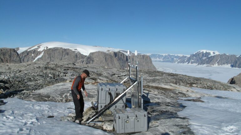
Data provided by state measurement stations in Greenland
Measurements are made using the Danish state’s GNET, which consists of 61 GNSS stations located around Greenland.
GNSS stands for the Global Navigation Satellite System, and it includes the American GPS system and the European Galileo. With GNSS technology, movements in the bedrock over time can be detected with sub-millimeter precision.
“We are pleased that data from the GNET stations is so widely used and gives us new opportunities to accurately monitor climate change in Greenland. For example, with the new measurement method developed by DTU. Therefore, we make a major effort to maintain and improve these measurement stations,” says Malte Nordmann Winther-Dahl, project manager for GNET at the Danish Geodata Agency, which is part of the Ministry of Climate, Energy and Utilities.
SDFI owns GNET, which is operated in collaboration with DTU.
So far, researchers and thus the IPCC have typically used three different methods to measure ice mass loss:

Gravity changes measured by NASA’s GRACE satellites, which can be converted into mass changes and ice loss
Direct changes in ice elevation measured by altimetry satellites
Measurement of ice movements via satellite and thus how much ice streams change over time. The faster the ice moves into the ocean, the more ice is lost from the ice sheet.
The study and the new method have been developed in collaboration between DTU Space and DTU Computing Center, located at DTU Compute. The center’s expertise and computing power have been crucial for handling large amounts of GPS data and running simulations in the project.
More information:
Valentina R. Barletta et al, GNET Derived Mass Balance and Glacial Isostatic Adjustment Constraints for Greenland, Geophysical Research Letters (2024). DOI: 10.1029/2023GL106891
Provided by
Technical University of Denmark
Citation:
New GPS-based method can measure daily ice loss in Greenland (2024, May 14)

