Densely populated coastal areas around the world experience an estimated relative sea level rise (the rise of the ocean with respect to the local land surface) of 7.8–9.9 millimeters (0.3–0.4 inch) per year. That’s 3–4 times the global average of 2.6 millimeters (0.1 inch) per year. These low-lying communities are vulnerable to storm surges from hurricanes, and their flooding risk can be compounded by land subsidence, or sinking.
To determine the risk of coastal flooding, researchers use tide gauges that estimate vertical land movement, GPS stations to better characterize spatial variations in this movement, and satellite measurement techniques such as interferometric synthetic aperture radar (InSAR) to fill in the gaps.
But GPS stations are sometimes widely spaced in rural areas, and InSAR satellite data can be hampered by dense vegetation, meaning subsidence isn’t always detected. This can lead to elevation change errors of up to approximately 1 centimeter (~0.4 inch) per year—a major margin of error when even a few millimeters of difference can affect flooding risk.
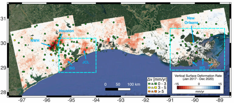
Ke Wang and colleagues developed a new strategy for processing InSAR data pertaining to more than 131,000 square kilometers (~50,579 square miles) of the U.S. Gulf Coast. Their approach, called EigenSAR, can map subsidence to within 2 millimeters (0.08 inch) of accuracy, even in densely vegetated terrain.
They validated their elevation readings with independently processed data collected from the nearly 200 GPS stations and tide gauges located within the satellite coverage area. The paper is published in the Journal of Geophysical Research: Earth Surface.
The team looked at Sentinel-1 InSAR satellite data along the Texas and Louisiana coasts from 2017 to 2020. In the greater Houston area, the city of Katy had the highest subsidence rate, at 20 millimeters (0.8 inch) per year, mainly as a result of groundwater pumping. The team also measured rural areas that were previously under-surveyed. In Chambers County, Texas, previous GPS estimates showed less than 5 millimeters per year of subsidence.
But with the new approach, the researchers found that 30% of the county subsides 10 millimeters (0.4 inch) or more per year. Most subsidence along the Texas-Louisiana coast was caused by groundwater pumping, oil and gas mining, and wetland degradation.
The authors note that their findings could help improve flood risk mapping, and that such maps, combined with socioeconomic data, could help focus flood mitigation efforts.
More information:
Ke Wang et al, Subtle Land Subsidence Elevates Future Storm Surge Risks Along the Gulf Coast of the United States, Journal of Geophysical Research: Earth Surface (2024). DOI: 10.1029/2024JF007858
Provided by
American Geophysical Union
This story is republished courtesy of Eos, hosted by the American Geophysical Union. Read the original story here.
Citation:
Subtle coastal sinking raises storm surge risks, new data analysis strategy suggests (2024, October 23)

