Sea ice around Antarctica shrank to the smallest extent on record in February, five years after the previous record low, researchers said Tuesday, suggesting Earth’s frozen continent may be less impervious to climate change than thought.
In late February, the ocean area covered by ice slipped below the symbolic barrier of two million square kilometers (around 772,000 square miles) for the first time since satellite records began in 1978, according to a study in the journal Advances in Atmospheric Sciences.
Researchers found that the key driver of ice loss was change in temperature, though shifts in ice mass also played a lesser role.
Both the North and South pole regions have warmed by roughly three degrees Celsius compared to late 19th-century levels, three times the global average.
Antarctica encountered its first recorded heatwave in 2020, with an unprecedented 9.2C above the mean maximum, and in March a research center in eastern Antarctica saw temperatures soar 30 degrees above normal.
But extreme aberrations of this kind are recent.
Unlike sea ice in the Arctic, which has diminished by three percent a year since the late 1970s, sea ice in Antarctica expanded over the same period by one percent per decade, albeit with large annual variations.
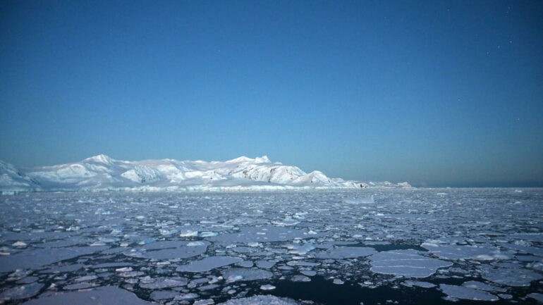
Ice cover during this year’s austral summer shrank most around West Antarctica, which has been more vulnerable to global warming than the far larger East Antarctica.
Sea-ice budget
Melting sea ice has no discernable impact on sea levels because the ice is already in ocean water.
But diminished ice cover is nonetheless a major concern because it helps accelerate global warming, explained co-author Qinghua Yang, a professor at Sun Yat-sen University in Guangzhou.
When white sea ice—which bounces the Sun’s energy back into space—is replaced by dark, unfrozen sea, “there is less reflection of heat and more absorption,” he said in a statement.
“This in turn melts more sea ice, producing more absorption of heat, in a vicious circle.”
Pristine snow and ice reflect more than 80 percent of the Sun’s energy back into space whereas open ocean absorb the same percentage.
Startlingly, the record low 1.9 million square kilometers on February 25 was 30 percent below the 1981-2010 average. The previous record was just over two million square kilometers in 2017.
Maximum sea ice extent in Antarctica has averaged about 18 million square kilometers in recent years.

To analyze the causes of this year’s record ice loss, researchers examined Antarctica’s “sea-ice budget”—ice added and ice lost, year by year—as well as daily sea-ice drift, or movement.
“In summer, thermodynamic”—or temperature-related—”processes dominate the sea melting through poleward heat transport,” the study concluded.
The record minimum sea ice extent in the Arctic—3.4 million square kilometers—occurred in 2012, with the 2nd and 3rd lowest ice-covered areas in 2020 and 2019, respectively. Maximum sea ice extent has averaged about 15 million square kilometers.
Ice sheets atop West Antarctica hold the equivalent of six meters of sea level rise, where as East Antarctica’s massive glaciers would raise global oceans by more than 50 meters.
2022 AFP
Citation:
Record low Antarctic sea ice extent could signal shift (2022, April 19)

