The Aedes aegypti mosquito is responsible worldwide for the spread of infectious diseases such as dengue, Zika, chikungunya, and yellow fever. To combat the widely transmitted diseases affecting millions, detailed mosquito distribution maps with data on the spatial and temporal spread of populations are of major importance.
Led by geoinformation scientists of Heidelberg University, an international research team has developed a new AI-supported method for mapping mosquito populations. Satellite and street view images are analyzed to more precisely assess the environmental conditions that favor the presence of Aedes aegypti. This is to improve planning of intervention measures and achieve more targeted disease control.
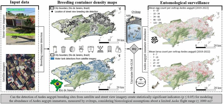
Also known as the Egyptian tiger mosquito, Aedes aegypti is mostly found in tropical and subtropical regions of the world—especially in cities, where it prefers to breed in man-made water containers such as drinking water tanks, car tires, trash, or plant pots. Because the global availability and acceptance of vaccines for the diseases it transmits are still limited, except for yellow fever, controlling mosquito populations is currently the most effective intervention.
Among the partly very cost-intensive measures of vector control are spraying insecticides as well as releasing mosquitoes infected with the naturally occurring bacterium Wolbachia. The bacterium can prevent virus transmission by Aedes aegypti and affect its propagation.
Implementing these control measures requires urban mosquito distribution maps, particularly in especially affected major cities such as Rio de Janeiro (Brazil).
“Precise maps are not only interesting from a financial standpoint to effectively plan mitigation measures but are also ecologically relevant, because some of these interventions, like extensive spraying of insecticides, harbor the risk of resistance development,” states Steffen Knoblauch, doctoral candidate at the Institute of Geography of Heidelberg University.
Until now, mosquito distribution maps have mostly been based on manual field measurements of single mosquito traps for a monthly count of eggs and larvae. In large urban areas, however, countless traps would have to be set up and large numbers of personnel deployed to maintain a reliable overview of the spread of mosquito populations.
Yet another challenge is the limited flight range of the mosquitoes, which is approximately 1,000 meters without wind assistance. This makes it difficult to derive distribution maps for major urban areas from mosquito trap measurements.
To overcome this problem, the geoinformation scientists of Heidelberg University developed a new approach to mapping mosquito populations.
“It utilizes the fact that the density of known breeding sites can be a significant predictor for the number of eggs and larvae measured in the traps, as shown by the investigations in Rio de Janeiro,” explains Prof. Dr. Alexander Zipf, head of the Geoinformatics/GIScience research group at the Institute of Geography and Director of the Heidelberg Institute for Geoinformation Technology (HeiGIT).
By leveraging artificial intelligence, the researchers analyze satellite and street view images to detect and map possible breeding sites in cities. In combination with field measurements, it is then possible to assess the environmental conditions that favor the presence of Aedes aegypti more precisely than before.
Together with researchers from Brazil, Prof Zipf’s team is also working on the analysis of mobile communications data to model the movement of people in Rio de Janeiro. In combination with precise mosquito distribution maps, these data can contribute to better trace the occurrence of infectious diseases transmitted by Aedes aegypti and incorporate the acquired knowledge into intervention maps. One challenge is the modeling of human movement patterns at different times of day since the mosquito tends to be active in the early morning and evening hours.

In addition to the Heidelberg geoinformation scientists, researchers from Austria, Brazil, Germany, Singapore, Thailand, and the U.S. contributed to the work. The research results were published in the journal Scientific Reports and the International Journal of Applied Earth Observation and Geoinformation.
More information:
Steffen Knoblauch et al, High-resolution mapping of urban Aedes aegypti immature abundance through breeding site detection based on satellite and street view imagery, Scientific Reports (2024). DOI: 10.1038/s41598-024-67914-w
Steffen Knoblauch et al, Semi-supervised water tank detection to support vector control of emerging infectious diseases transmitted by Aedes Aegypti, International Journal of Applied Earth Observation and Geoinformation (2023). DOI: 10.1016/j.jag.2023.103304
Provided by
Heidelberg University
Citation:
Geoinformatics: Using AI to take better aim against mosquitoes (2024, September 2)

