As soldiers and citizens provide information from the front lines and affected areas of the war in Ukraine – two years old as of Feb. 24, 2024 – in quasi-real time, an active open-source intelligence community has formed to keep track of troop activity, destruction and other aspects of the war.
Remote sensing complements this approach, offering a safe means to study inaccessible or dangerous areas. For example, seismologists have documented the high pace of bombardments and firing of artillery around Kyiv during the first few months of the war.
Previously, Teng Wang, a professor at the Peking University in China, and I – both Earth scientists – studied illegal nuclear tests in North Korea with satellite data.
Putting our skills to good use once again, we, with graduate student Hang Xu, have analyzed the development of the war from space. We exclusively used open-source, freely accessible data to ensure that all our findings could be reproduced, guaranteeing transparency and neutrality.
View from above
Sensors on satellites record electromagnetic waves radiated or reflected from Earth’s surface with wavelengths ranging from hundreds of nanometers to tens of centimeters, enabling semi-continuous monitoring on a global scale, unimpeded by political boundaries and natural obstacles.
Optical images, the equivalent of photographs taken from space, help governments, researchers and journalists monitor troop movements on the front and the destruction of equipment and facilities. Although optical images are easily interpreted, they suffer from cloud cover and operate only during daylight.
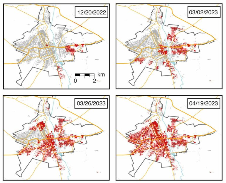
To counter these issues, we used radars onboard satellites. Space-borne radar systems beam long-wavelength electromagnetic waves toward the Earth and then record the returning echos. These waves – about 0.4 to 4 inches (1 to 10 centimeters) – can penetrate clouds and smoke. Radar interferometry has already proved to be an invaluable tool to monitor widespread damage caused by natural disasters.
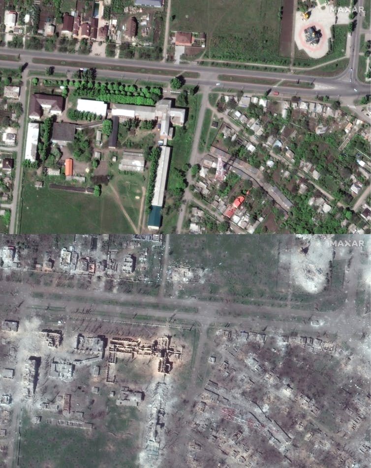

Satellite photography like these ‘before’ and ‘after’ images can provide a visceral sense of the destruction in the war in Ukraine.
Satellite image (c) 2023 Maxar Technologies via Getty Images
Radar from space
Free and publicly available radar data for civilian applications is rare – the United States is scheduled to launch its first one in March 2024 – but the European Space Agency has made such data available since the early 1990s. Data from the European Space Agency’s Sentinel-1 satellite radar is freely accessible via their data hub.
Two radar images formed over the same area can be used to detect changes to structures and other surfaces. Interferometry measures the difference in travel time between two radar signals, which is a measure of change in the shape or position of surfaces. Another measure of surface change is the coherence of the reflected signals – that is, the degree of…

