As rising seas threaten to flood hundreds of toxic sites along the California coast, the risk of flood-related contamination will fall disproportionately on the state’s most marginalized communities, finds a new study published today by researchers at UC Berkeley, UCLA and Climate Central.
Under California’s high-risk aversion scenario, which projects that sea levels could rise by more than 6 feet by the end of the century, the study identified 736 facilities at risk of coastal flooding and an additional 173 with projected groundwater encroachment. Residents living within 1 kilometer of at-risk sites were more likely than others to be people of color, to be living below the poverty line, to be unemployed or to experience another form of social disadvantage such as linguistic isolation.
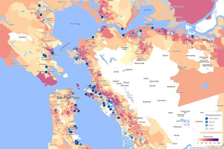
As part of the study, the researchers also released a new interactive online tool in English and Spanish that allows users to map toxic sites that are at risk of coastal flooding, either by county or by individual facility. Users can also overlay indicators of nearby residents’ social vulnerability, including the percentage of people who are living below the poverty line, who are experiencing unemployment, or who don’t have a high school degree.
“Sea level rise is like a slow-moving storm that we can anticipate and prepare for,” said Rachel Morello-Frosch, a professor of public health and of environmental science, policy and management at UC Berkeley and senior author of the paper. “As California invests in community resilience to climate change, it is essential that considerations of environmental justice are at the fore.”

A map of hazardous sites at risk of coastal flooding in the San Francisco Bay Area, generated by the new coastal risk screening tool available on the Climate Central website. The colored overlay indicates the poverty level of nearby communities. © Climate Central
Low-income communities and communities of color already face disproportionate exposure to myriad environmental pollutants, and the threat of additional exposures from sea-level rise will only exacerbate these inequities. Compared to their neighbors, socially vulnerable residents can also face more challenges to evacuate during a flood and often experience social stressors that can make them more susceptible to the health impacts of pollutant exposures.
San Mateo and Alameda counties are projected to host the most at-risk hazardous sites by 2050, but by 2100, Orange County is projected to surpass both as oil and gas wells there and in Los Angeles County face rising coastal flood risks.
“Again, climate change amplifies inequality,” said lead author Lara Cushing, an assistant professor of environmental health sciences at the UCLA Fielding School of Public Health. “Sea level rise will present additional risks of contaminant releases to communities already living with pollution sources in their backyards.”
The study was conducted as part of the Toxic Tides project, which brought together a multidisciplinary research team with community advocacy organizations to understand how rising seas would impact hazardous sites, including refineries, industrial facilities, sewage treatment plants and cleanup sites. The team released a preliminary set of data and an earlier version of the online mapping tool in November 2021; the new study, which appears in the journal Environmental Science and Technology, includes additional analysis about the environmental justice implications of the findings.
More information:
Lara J. Cushing et al, Toxic Tides and Environmental Injustice: Social Vulnerability to Sea Level Rise and Flooding of Hazardous Sites in Coastal California, Environmental Science & Technology (2023). DOI: 10.1021/acs.est.2c07481
Provided by
University of California – Berkeley
Citation:
As rising seas disrupt toxic sites, study finds communities of color are at most risk (2023, May 3)


