A new study used artificial intelligence to analyze 10 years of weather data collected over southeastern Texas to identify three major categories of weather patterns and the continuum of conditions between them. The study, just published in the Journal of Geophysics Research: Atmospheres, will help scientists seeking to understand how aerosols—tiny particles suspended in Earth’s atmosphere—affect the severity of thunderstorms.
Do these tiny particles—emitted in auto exhaust, pollution from refineries and factories, and in natural sources such as sea spray—make thunderstorms worse? It’s possible, said Michael Jensen, a meteorologist at the U.S. Department of Energy’s (DOE) Brookhaven National Laboratory and a contributing author on the paper.
“Aerosols are intricately connected with clouds; they’re the particles around which water molecules condense to make clouds form and grow,” Jensen explained.
As principal investigator for the TRacking Aerosol Convection interactions ExpeRiment (TRACER)—a field campaign taking place in and around Houston, Texas, from October 2021 through September 2022—Jensen is guiding the collection and analysis of data that may answer this question. TRACER uses instruments supplied by DOE’s Atmospheric Radiation Measurement (ARM) user facility to gather measurements of aerosols, weather conditions, and a wide range of other variables.
“During TRACER, we are aiming to determine the influence of aerosols on storms. However, those influences are intertwined with those of the large-scale weather systems (think of high- or low-pressure systems) and local conditions,” Jensen said.
To tease out the effects of aerosols, the scientists have to disentangle those influences.
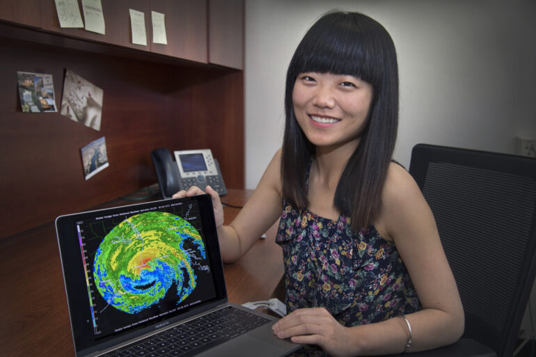
Dié Wang, an assistant meteorologist at Brookhaven Lab and lead author of the paper looking back at 10 years of data prior to TRACER, explained the approach for doing just that.
“In this study, we used a machine learning approach to determine the dominant summertime weather condition states in the Houston region,” she explained. “We will use this information in our TRACER analysis and modeling studies by comparing storm characteristics that occur during similar weather states but varying aerosol conditions.”
“That will help us to minimize the differences that are due to the large-scale weather conditions, to help isolate the effects of the aerosols,” she said.
The project is the first step toward fulfilling the goals supported by DOE Early Career funding awarded to Wang in 2021.
Bringing students on board
The study also provided an opportunity for several students involved in virtual internships at Brookhaven Lab to contribute to the research. Four co-authors were participants in DOE’s Science Undergraduate Laboratory Internship (SULI) program, and one was interning as part of Brookhaven’s High School Research Program (HSRP).
Each intern investigated the variability of different cloud and precipitation properties among the weather categories using datasets from radar, satellite, and surface meteorology measurement networks.

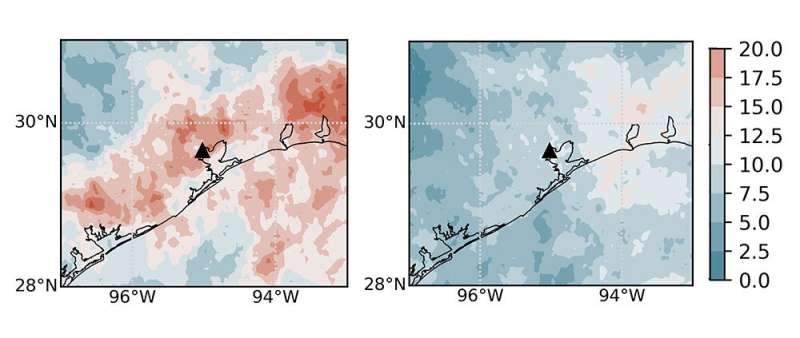
These maps show the frequency of storms (from 0-20%) over southeastern Texas calculated using 10 years of satellite data during high-pressure (left) and low-pressure (right) conditions. The high-pressure regime is favorable for sea-breeze induced storms to develop over the region and these storms may be more impacted by aerosols. © Brookhaven National Laboratory
“This work was well suited to the virtual internship as it was largely driven by computational data analysis and visualization,” Jensen said. “The interns gained valuable experience in computer programming, real-world scientific data analysis, and the complexities of Earth’s atmospheric system.”
Dominic Taylor, a SULI intern from Pennsylvania State University, wrote about his experience for an ARM blog:
“At first, I faced a lot of challenges…with my computer being able to handle the size and number of data files I was using….Dié, Mike, and my fellow interns were always there when I needed help,” he said.
“Given my passion for meteorology, I was psyched to have this position in the first place, but writing code and spending probably way too long formatting plots didn’t feel like work because I found the topic so fascinating,” he added.
In the same blog post, Amanda Rakotoarivony, an HSRP intern from Longwood High School, said, “this internship allowed me to truly connect the topics I’ve learned in school to the real-world research that’s being done….[and] showed me how research and collaboration is interdisciplinary at the core.”
Details of the data
The southeastern Texas summer weather is largely driven by sea- and bay-breeze circulations from the nearby Gulf of Mexico and Galveston Bay. These circulations, in conjunction with those from larger-scale weather systems, affect the flow of moisture and aerosol particles into the Houston region and impact the development of thunderstorms and their associated rainfall. Understanding how these flows affect clouds and storms is important to improving models used for weather forecasts and climate predictions. Categorizing patterns can help scientists assess the effects of other influences, including aerosols.
To characterize the weather patterns, the scientists used a form of artificial intelligence to analyze 10 years of data that combines climate model results with meteorological observations.
“The combined data produces a complete, long-term description of three-dimensional atmospheric properties including pressure, temperature, humidity, and winds,” said Wang.
The scientists used a machine-learning program known as “Self-Organizing Map” to sort these data into three dominant categories, or regimes, of weather patterns with a continuum of transitional states between them. Overlaying additional satellite, radar, and surface-based observations on these maps allowed the scientists to investigate the characteristics of cloud and precipitation properties in these different regimes.
“The weather regimes we identified pull together complex information about the dominant large-scale weather patterns, including factors important for the formation and development of storms. By looking at how the storm cloud and precipitation properties vary under different aerosol conditions but similar weather regimes, we are able to better isolate the effects of the aerosols,” Wang said.
The team will use high-resolution weather modeling to incorporate additional local-scale meteorology measurements—for example, the sea-breeze circulation—and detailed information about the number, sizes, and composition of aerosol particles.
“This approach should allow us to determine exactly how aerosols are affecting the clouds and storms—and even tease out the differing effects of industrial and natural sources of aerosols,” Wang said.
More information:
Dié Wang et al, Linking Synoptic Patterns to Cloud Properties and Local Circulations Over Southeastern Texas, Journal of Geophysical Research: Atmospheres (2022). DOI: 10.1029/2021JD035920
Provided by
Brookhaven National Laboratory
Citation:
Classifying weather to tease out how aerosols influence storms (2022, March 22)


