The magnitude 4.8 Tewksbury earthquake surprised millions of people on the U.S. East Coast who felt the shaking from this largest instrumentally recorded earthquake in New Jersey since 1900.
But researchers noted something else unusual about the earthquake: why did so many people 40 miles away in New York City report strong shaking, while damage near the earthquake’s epicenter appeared minimal?
In a paper published in The Seismic Record, YoungHee Kim of Seoul National University and colleagues show how the earthquake’s rupture direction may have affected who felt the strongest shaking on 5 April.
Kim and her colleague and co-author Won-Young Kim of Lamont-Doherty Earth Observatory of Columbia University became curious about the strange pattern of shaking after visiting the epicenter area of the earthquake just eight hours after the mainshock.
“We expected some property damage—chimneys knocked down, walls cracked or plaster fallen to the ground—but there were no obvious signs of property damage,” the researchers said in an email. “Police officers within a couple of kilometers from the reported epicenter calmly talked about the shaking from the main shock. It was a surprising response by the people and houses for a magnitude 4.8 earthquake in the region.”
“This contrasted with the wide and huge response from the residents in and around the New York City area, some 65 kilometers from the epicenter,” they added.
The earthquake garnered more than 180,000 felt reports—the largest number ever for a single earthquake received by the U.S. Geological Survey’s “Did You Feel It?” app and website, according to a second paper published in The Seismic Record by USGS seismologist Oliver Boyd and colleagues.
Boyd and colleagues said the earthquake was felt by an estimated 42 million people between Virginia and Maine.
The reports from people southwest of the epicenter, toward Washington, D.C., indicated “weak” shaking on the scale that the USGS uses to measure an earthquake’s intensity, while people reporting from northeast of the epicenter felt “light to moderate” shaking.
Based on previous models of magnitude and earthquake intensity developed for the eastern U.S., however, a magnitude 4.8 earthquake should produce very strong shaking within about 10 kilometers or about six miles from its epicenter.
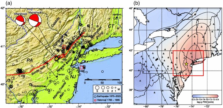
With this pattern in mind, Kim and colleagues wanted to look closer at the directivity of the earthquake’s rupture. To model the rupture, they turned to a kind of seismic wave called Lg waves, due to the lack of nearby seismic observation at the time of the mainshock. Lg waves are shear waves that bounce back and forth within the crust between the Earth’s surface and the boundary between the crust and mantle.
The resulting model indicated the earthquake rupture had propagated toward the east-northeast and down on an east-dipping fault plane. The direction of the rupture might have funneled the earthquake’s shaking away from its epicenter and toward the northeast, the researchers concluded.
In general, earthquakes in the northeastern U.S. take place as thrust faulting along north-south trending faults. The New Jersey earthquake is unusual, Kim and colleagues noted, because it appears to have been a combination of a thrust and strike-slip mechanism along a possible north-northeast trending fault plane.
“Earthquakes in eastern North America usually occur along the pre-existing zone of weakness—that is, existing faults,” the researchers explained. “In the Tewksbury area, a hidden fault plane trending north-northeast and dipping moderately can be mapped from the numerous small aftershocks detected and located” after the Tewksbury mainshock.
Boyd and colleagues noted that some damage was documented by a reconnaissance team deployed by the Geotechnical Extreme Events Reconnaissance Association and the National Institute of Standards and Technology. Along with cracks in drywall and objects falling from shelves, the team documented the partial collapse of the stone façade of Taylor’s Mill, a pre-Revolutionary War structure near the town of Lebanon, New Jersey.
The researchers have not yet attributed the earthquake to a particular fault but the locations of the mainshock and aftershocks suggest that the area’s well-known Ramapo fault system was not active during the earthquake.
The findings could “help us identify new earthquake sources and rethink how stress and strain are being accommodated in the eastern United States,” Boyd said.
He noted that some seismometers that were rapidly deployed to the region by the USGS will remain in place for at least five months.
“This can help us study, for example, mechanisms related to how the crust responds to the stress of a mainshock in the region, and how productive aftershock sequences can be in the eastern United States,” Boyd explained.
“Good station coverage can also allow us to observe how earthquake ground motions vary across the region as a function of magnitude, epicentral distance, and Earth structure. And each of these examples can help us better appreciate potential seismic hazards.”
More information:
Sangwoo Han et al, Rupture Model of the 5 April 2024 Tewksbury, New Jersey, Earthquake Based on Regional Lg-Wave Data, The Seismic Record (2024). DOI: 10.1785/0320240020
Oliver S. Boyd et al, Preliminary Observations of the 5 April 2024 Mw 4.8 New Jersey Earthquake, The Seismic Record (2024). DOI: 10.1785/0320240024
Provided by
Seismological Society of America
Citation:
Closer look at New Jersey earthquake rupture could explain shaking reports (2024, October 2)

