Rapid access to information is one of the largest barriers we have to deal with as a group of people in the Internet Age. Earth Map is a free application designed to be easily used and accessible to anyone with an internet connection and the desire to observe any environment at any time, with zero expertise (or travel) required.
This new tool features an intuitive point-and-click way of interfacing with the program, lending further to its ease of use.
The researchers published their results on January 12 in the Journal of Remote Sensing. The authors underline the importance of getting their technology out into the hands of the public who can make change happen.
“Earth Map allows to transform big data into actionable information by everyone, thus democratizing the application of remotely sensed data. It enables a broader array of actors to take an active role in monitoring lands currently impacted by human activities,” said Carmen Morales, lead author and researcher at the Food and Agriculture Organization (FAO) of the United Nations.
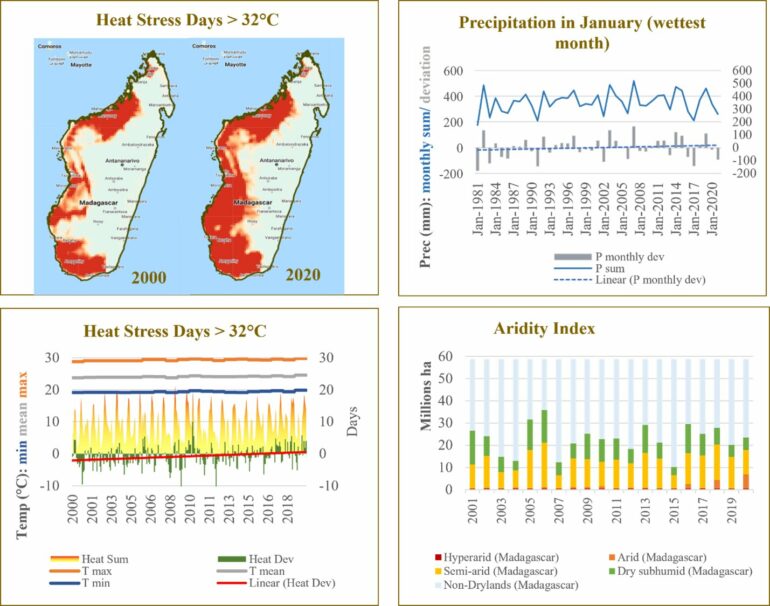
With a wide array of users comes a large amount of data that can be used for environmental monitoring and remote sensing applications. Earth Map uses Earth Observation (EO) data to measure various parameters (such as temperature, rainfall or vegetation) to keep track of the climate and environment and how it changes year over year.
These parameters can be used to measure how well natural resources are managed and give people insight into how human interactions with the environment can have direct and long-lasting impacts on the earth as we currently know it.
“The next 10 years will be decisive to avoid catastrophic climate change effects and mass extinctions. More than 3 quarters of Earth’s land surface is impacted by human activity. It is therefore more important than ever that countries, organizations, communities, and individuals are conscious of current, past, and future land characteristics and dynamics,” said Morales. While 10 years is not a lot of time, there can be exponential improvements in policy change to drive large-scale action.
Ideally, Earth Map is a tool that can be used to introduce the subject of climate and resource/land usage to users such as policy-makers, research institutions, and interested citizens who have the interest but no prior knowledge of navigating software geared towards environmental and climate analysis.
Since the climate is largely affected by policies established by governing bodies, the goal would be to use Earth Map as a jumping-off point for decision-makers at different levels to inform themselves of the current state of the climate and what meaningful policy changes can be enacted to navigate away from climate disaster.
“Using the app at its full capacity, Earth Map is a powerful tool to undertake research on the world’s most pressing environmental problems and the impacts of the climate change emergency and develop science-based policy interventions, leverage investments, and sustain livelihoods,” Morales said.
The app will help to provide researchers and institutions with valuable data to further delve into the science of climate and resource management to hopefully bring about a more sustainable world.
More information:
Carmen Morales et al, Earth Map: A Novel Tool for Fast Performance of Advanced Land Monitoring and Climate Assessment, Journal of Remote Sensing (2023). DOI: 10.34133/remotesensing.0003
Provided by
Journal of Remote Sensing
Citation:
Free app works in tandem with its users to achieve a more conscious, climate-aware and environmental-friendly world (2023, March 10)


