
Tropical forests are clearly critical to Earth’s climate system, but understanding exactly how much carbon they absorb from the atmosphere, store and release is tricky to calculate, not least because measuring and reporting methods vary. With these measurements paramount for nations assessing the action they are taking to combat the climate crisis, new research shows how differences in estimates of carbon flux associated with human activity can be reconciled.
The research, published recently in the Carbon Balance and Management journal, describes why there can be a gap between carbon flux estimates based on data from Earth-observing satellites and country estimates given in National Greenhouse Gas Inventories.
Net forest carbon flux is the net exchange of carbon between forests and the atmosphere, calculated as the balance between carbon emitted and carbon sequestered by forests, per hectare over a given period.
Satellites provide independent information to show how forests change over time, which allows rates of carbon flux to be estimated. These measurements can then be compared to results reported in National Greenhouse Gas Inventories.
However, this approach can throw up discrepancies.
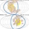
The published paper highlights the example of Brazil where estimates using Earth observation data indicated that, between 2001 and 2020, the country as a whole was as a net carbon sink. This contrasts to the country’s inventory, which showed that human activity resulted in forests in Brazil being a net carbon source.
A carbon source releases more carbon than it absorbs, from activities such as deforestation, logging and fire. A carbon sink is a reservoir that absorbs more carbon from the atmosphere than it releases owing to the ongoing growth of standing forests and the restoration of new forests.
Viola Heinrich, from the University of Bristol and the German Research Center for Geoscience, and lead author of the paper, said, “A key reason why there can be discrepancies between datasets derived from satellites compared to what is reported in inventories can be linked to whether or not a piece of land is considered as managed by humans.
“National reports can define an area of forest as managed, but satellites cannot distinguish whether they are managed or natural.
")
Brazilian forest carbon flux 2001–2020. © ESA (source: Heinrich et al., 2023)
“When we adjust Earth observation datasets to land declared as managed in the National Greenhouse Gas Inventories, the estimates can then align.”
The research team focused on three countries as case studies: Brazil as the primary case study, Indonesia and Malaysia.
After adjusting the satellite estimates to use the Brazilian National Greenhouse Gas Inventory’s definition of managed forest and other assumptions in the inventory’s methodology, the Earth observation net flux became a source of +0.6 Gt of carbon dioxide per year, which is comparable to that stated in the inventory.
In Indonesia, the satellite dataset and the inventory net flux estimates were similar: a source of +0.6 Gt of carbon dioxide per year.
However, in Malaysia, there was a considerable difference. The inventory stating that at –0.2 Gt carbon dioxide a year their forests were a sink, but the satellite data indicated that the forests were a source of +0.2 Gt carbon dioxide a year.
Dr. Heinrich continued, “Despite limited spatial data available for Indonesia and Malaysia, our comparison indicated specific aspects where differing approaches may explain divergence, including uncertainties and inaccuracies
“Moreover, our study highlights the importance of enhanced transparency, as set out by the Paris Agreement, to enable alignment between different approaches for independent measuring and verification.”
ESA’s Clement Albergel added, “This research has very important implications for our ESA Climate Change Initiative Regional Carbon Cycle Assessment and Processes Phase-2 (RECCAP-2) project.
“The project supports and accelerates the analysis of regional carbon budgets based on the results of top-down atmospheric inversion as well as bottom-up data-driven models and process-oriented global dynamic vegetation models. Bottom-up inventories only report fluxes on managed lands, so, inversions have to be sampled over managed lands.
“Using a similar approach as outlined in the recent published paper, will now be able to better reconcile top-down inversions and National Greenhouse Gas Inventories.”
More information:
Viola Heinrich et al, Mind the gap: reconciling tropical forest carbon flux estimates from earth observation and national reporting requires transparency, Carbon Balance and Management (2023). DOI: 10.1186/s13021-023-00240-2
Provided by
European Space Agency
Citation:
Minding the gap on tropical forest carbon: Reconciling data from Earth-observing satellites with national reporting (2023, December 7)

