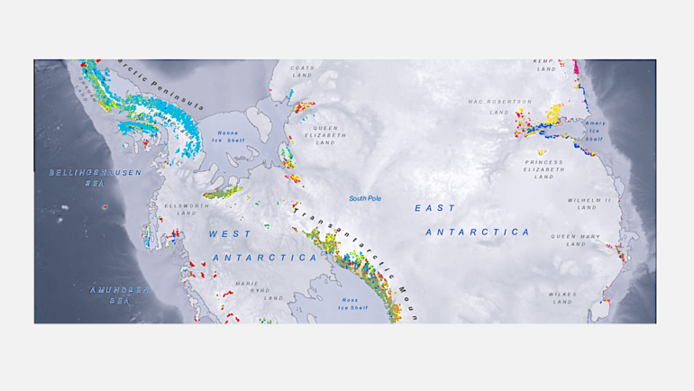
GeoMAP Antarctica, an open-access and comprehensive geological mapping database of Antarctica, was released May 18 in the journal Scientific Data. Understanding Antarctica’s geosphere is, and has been, critical for understanding the continent’s major role in global climate—and thus, our future.
Constructing GeoMAP was a large, and long-term, international effort from Scientific Committee on Antarctic Research (SCAR), led by GNS Science in New Zealand. The project involved principal collaborators from U.S., Norway, Italy, UK, Australia, Russia and New Zealand—including British Antarctic Survey Field Geologist, Dr. Alex Burton-Johnson.
Despite Antarctica’s reputation as an icy expanse, over 52,000 km2 of exposed rock and sediment make up the mountains and surfaces of the continent. Each of these areas contain important information on the continent’s geological, geomorphological, and glaciological history. Put simply, rocks play an important role in—and tell us a lot about—the complex interaction of land, atmosphere, and climate. Geological knowledge of the continent’s mountains, sediments and soils, helps pinpoint the location, history and movement of glaciers, and even meltwater production. These insights provide foundational knowledge for researchers, from climate scientists, to biologists, to ecologists and volcanologists.
Today, GeoMAP is the first detailed, digital, open-access database that collates all the historical, and existing, geological data of Antarctica. Geological study has taken place in Antarctica for over a century, so constructing GeoMAP to compile the existing geological knowledge into one place, took several years. The research effort included interpreting information from beautiful 20th century hand-drawn maps, digitizing hard-copy regional maps, and then integrating them with modern high-resolution datasets.
Lead data architect, Belinda Smith Lyttle from GNS Science says, “There are still many areas in Antarctica yet to be visited by any geologist, and other areas where very detailed mapping has yet to be captured—and there is always new research taking place—so the GeoMAP database has been designed to be editable and improved over time.”
More information:
Simon C. Cox et al, A continent-wide detailed geological map dataset of Antarctica, Scientific Data (2023). DOI: 10.1038/s41597-023-02152-9
Provided by
British Antarctic Survey
Citation:
New map unlocks deep digital data of Antarctica’s history (2023, May 22)

