If the bedrock in the Alps no longer remains permanently frozen, rockfalls may occur more frequently. By measuring electrical resistivity in the ground, researchers can now better understand why this happens.
The disappearance of the glaciers is visible to us all. What is happening to the alpine bedrock is less obvious. The permafrost is thawing there. And that has consequences: When the underground ice melts, it can destabilize mountain slopes, change the landscape and endanger people and their infrastructure.
This is why Swiss researchers have been monitoring the state of permafrost in the mountains for many decades. The conventional method is to drill holes of up to a depth of 100 meters to measure ground temperatures. However, this is time-consuming and expensive—especially at high altitudes.
“You also only know the temperature at certain points and cannot make any statements about the volume of ice,” says geoscientist Christian Hauck. In recent years, he and his team at the University of Fribourg have co-developed a non-invasive measurement method that measures permafrost over large areas, determines the amount of ice, and thus makes it possible to forecast future developments.
Like computer tomography for the ground
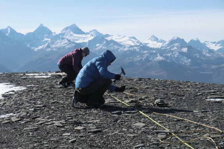
The basic principle is simple: the researchers conduct direct electrical current through the ground between two electrodes and measure the electrical potential difference at numerous other electrodes in the ground. The resulting electrical resistivity depends on the state of the water—ice is less conductive than liquid water and so it has a greater resistivity. If there is no water in the ground at all, the resistivity is even higher. The measurements therefore provide information on whether water is present in liquid or frozen form, and if so, how much there is.
“Similar to a CT scan in medicine, we sometimes take over a thousand individual measurements to obtain a three-dimensional image,” explains Hauck. To do this, the researchers place close to 50 electrodes on an area of about half a hectare. The further apart the electrodes are, the deeper the current penetrates. “At such high altitudes, it is not always easy to find suitable places for the electrodes. We also have to keep our own safety in mind,” reports Hauck on his fieldwork.
A loss of 15% in seven years
Calculating the distribution and quantity of permafrost from the measured data is even more difficult, especially since there are numerous other factors to consider in the mountains, such as the characteristics of the rock layers and the inclination of the slope. However, the model for the calculation is being refined on a continuous basis.
It is also useful to compare the results with data collected via other methods; for instance, the Swiss Permafrost Monitoring Network (PERMOS) has been measuring temperatures on the surface and in boreholes at many locations in the Alps for two decades.
In a study recently published in Environmental Research Letters, doctoral student Sarah Morard and Hauck’s team analyzed all the data available on the permafrost on the slopes of the Stockhorn above Zermatt. Temperatures in the boreholes have risen by about 1°C over the last 20 years, and the permafrost is now located several meters deeper in the ground.
The resistivity measurements described above also made it possible to quantify the loss of permafrost for the first time: about 15% of the ice was lost between 2015 and 2022.
Predicting the tipping points
In another study, also published in Environmental Research Letters, Hauck and his colleague Christin Hilbich analyzed data from resistivity measurements taken throughout Europe. This showed that even a single hot summer—such as in 2003, 2015 and 2022—can lead to the irreversible loss of permafrost in the mountains.
A subsequent cold winter is not sufficient to compensate for the loss. “Very specific conditions are needed for permafrost to form again,” says Hauck. For example, it has to rain when it is extremely cold so that ice can form before the water drains back into the valley.
Using the resistivity data, Hauck can now reconstruct such processes in the past and make predictions for the future. He believes that the alpine permafrost has already reached or will soon reach the tipping point in many places. This means that the disappearance of permafrost will then speed up on its own and can no longer be stopped without significant changes to the climate.
Depending on the geological conditions, this could then lead to increased rockfalls or landslides in places where they were previously not possible, such as on slopes where geological layers are stabilized by permafrost. It is therefore all the more important to establish methods that predict such tipping points as early and reliably as possible, says Hauck.
More information:
S Morard et al, 20-year permafrost evolution documented through petrophysical joint inversion, thermal and soil moisture data, Environmental Research Letters (2024). DOI: 10.1088/1748-9326/ad5571
Christian Hauck et al, Preconditioning of mountain permafrost towards degradation detected by electrical resistivity, Environmental Research Letters (2024). DOI: 10.1088/1748-9326/ad3c55
Provided by
Swiss National Science Foundation
Citation:
New methods predict tipping points for alpine permafrost loss (2024, July 30)


