When it comes to greenhouse gases, methane is one the biggest contributors. Not only is it massively abundant—it’s about 25 times more potent than carbon dioxide at trapping heat in the atmosphere.
That makes tracking methane emissions critically important, and nowhere more so than in the Arctic, which is now the fastest warming part of the globe.
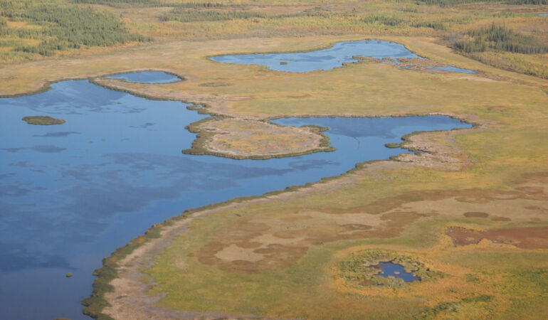
A new study conducted at Brown University helps shed light on the actual atmospheric methane emissions from Arctic lakes and wetlands, which are major producers of the gas but remain largely unmapped. The findings have been published in Geophysical Research Letters.
Using unprecedented high-resolution satellite and airborne imagery from NASA—harnessing the technology to overcome barriers posed by the region’s sheer size and numerous natural land formations that are major methane producers—a pair of researchers produced new estimates and found that these unmapped lakes are not the great methane emitters that previous research has made them out to be.
Instead of contributing about 40% of the region’s methane emissions, small unmapped lakes contribute only about 3%, according to the study.
“What the research has shown is that these smaller lakes are the greater emitters of methane on a per area basis, which means even that though they take up a small amount of the landscape they have a disproportionate level of emissions,” said Ethan D. Kyzivat, who led the study as part of his Ph.D. at Brown.
“Traditionally, we haven’t had a good picture of how much area they take up, but this new high-resolution dataset helped us scale it up to finally make those estimations much more accurately.”
These new findings contradict close to 15 years of research based on older datasets with much lower resolution quality. In the older data, the number of small lakes that could be seen were statistically extrapolated to produce estimates for the region on the total number of small unmapped lakes and how much methane they emitted.
The new analysis of the aerial imagery showed the researchers, including Brown professor Laurence C. Smith, that there are far fewer small, unmapped lakes than were previously estimated, greatly reducing the cumulative amount of methane they were thought to emit.
The study focuses on small lakes that are about a tenth of a square kilometer or smaller, which is equivalent to about 20 football fields. Kyzivat, who’s now a postdoctoral researcher at Harvard University, spent more than two years working on the study, initially compiling the data while working on his master’s degree and analyzing and writing the paper while working on his Ph.D. at Brown.
The project started as an effort to look for hidden lakes in the Arctic but morphed as the researchers examined the data more closely. The effort, which involved combining the high-resolution airborne data with a global map of lakes in the Arctic region, also unearthed a couple of unexpected but welcome results.
The work, for instance, shows that a lot of small and large lakes are still being double-counted as wetlands. This double-counting pumps methane emission estimates for the region, but taken with the new findings of fewer unmapped small lakes, the researchers believe the problem is on a smaller magnitude than what was previously thought.
Another unexpected result comes in methodology.
In the methane modeling field, there are two widely held trains of thought. One is “bottom up” estimates, which model methane emissions based on maps of the Earth, as the researchers do here. The other method is “top down” estimates, which model methane based on atmospheric measurements. For more than a decade, there has been a perplexing discrepancy between the figures produced by these two methods, according to Smith.
The new figures from the analysis may help reconcile the two opposing viewpoints by closing the difference between them.
“It’s probably been 15 to 20 years of loggerheads, but the takeaway is the satellite resolution is now there for the ‘bottom-up’ community to take a much better look at how much methane is actually being emitted,” said Smith, who is a professor of environmental studies and of earth, environmental and planetary sciences.
“We can now actually see the very smallest of these water bodies and they’re not as abundant as we were extrapolating. The end result of all of this is going to reduce the bottom-up estimates to make them fall more in line with the top-down estimates. It’s going to unify these two communities.”
Because of this, Kyzivat and Smith see the work from the study as a proof of concept and now look to expand their methane modeling technique to other parts of the world.
“The next step is to go global,” Kyzivat said.
More information:
A Closer Look at the Effects of Lake Area, Aquatic Vegetation, and Double‐Counted Wetlands on Pan‐Arctic Lake Methane Emissions Estimates, Geophysical Research Letters (2023). DOI: 10.1029/2023GL104825
Citation:
New study sheds light on how much methane is produced from Arctic lakes and wetlands (2023, December 12)


