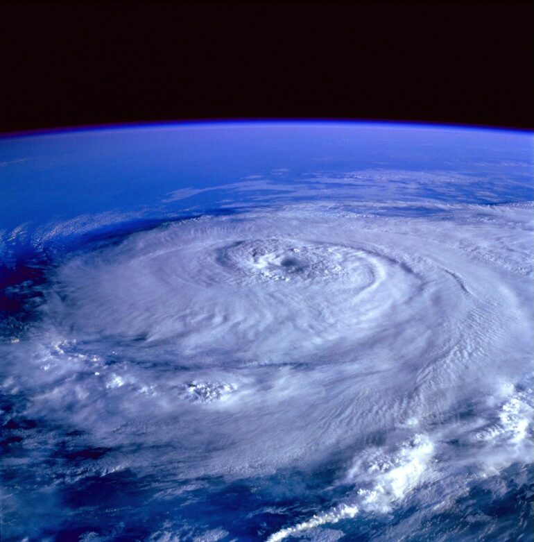
Hurricanes that rapidly intensify for mysterious reasons pose a particularly frightening threat to those in harm’s way. Forecasters have struggled for many years to understand why a seemingly commonplace tropical depression or tropical storm sometimes blows up into a major hurricane, packing catastrophic winds and driving a potentially deadly surge of water toward shore.
Now scientists have shed some light on why this forecasting challenge has been so difficult to overcome: There’s more than one mechanism that causes rapid intensification. New research by scientists at the U.S. National Science Foundation (NSF) National Center for Atmospheric Research (NCAR) uses the latest computer modeling techniques to identify two entirely different modes of rapid intensification. The findings may lead to better understanding and prediction of these dangerous events.
The new study appeared in the Monthly Weather Review. It was co-authored by NCAR scientists Rosimar Rios-Berrios and George Bryan.
“Trying to find the holy grail behind rapid intensification is the wrong approach because there isn’t just one holy grail,” said NCAR scientist Falko Judt, lead author of the new study. “There are at least two different modes or flavors of rapid intensification, and each one has a different set of conditions that must be met in order for the storm to strengthen so quickly.”
One of the modes discussed by Judt and his co-authors occurs when a hurricane intensifies symmetrically, fueled by favorable environmental conditions such as warm surface waters and low wind shear. This type of abrupt strengthening is associated with some of the most destructive storms in history, such as Hurricanes Andrew, Katrina, and Maria. Meteorologists were stunned this week when the winds of Hurricane Otis defied predictions and exploded by 110 miles per hour in just 24 hours, plowing into the west coast of Mexico at category 5 strength.
Judt and his co-authors also identified a second mode of rapid intensification that had previously been overlooked because it doesn’t lead to peak winds reaching such destructive levels. In the case of this mode, the strengthening can be linked to major bursts of thunderstorms far from the storm’s center. These bursts trigger a reconfiguration of the cyclone’s circulation, enabling it to intensify rapidly, reaching category 1 or 2 intensity within a matter of hours.
This second mode is more unexpected because it typically occurs in the face of unfavorable conditions, such as countervailing upper-level winds that shear the storm by blowing the top in a different direction than the bottom.
“Those storms are not as memorable and they’re not as significant,” Judt said. “But forecasters need to be aware that even a storm that’s strongly sheared and asymmetric can undergo a mode of rapid intensification.”
A serendipitous finding
Rapid intensification occurs when the winds of a tropical cyclone increase by 30 knots (about 35 miles per hour) in a 24-hour period. Judt came across the two modes of rapid intensification when working on an unrelated project.
The discovery emerged after Judt produced a very high-resolution, 40-day computer simulation of the global atmosphere, using the NCAR-based Model for Prediction Across Scales (MPAS). That simulation, run at the NCAR-Wyoming Supercomputing Center, was designed for an international project comparing the output of leading atmospheric models, which have achieved unprecedented detail because of increasingly powerful supercomputers.
Once Judt produced the model, he was curious to examine storms in the simulation that rapidly intensified. By looking at a number of cases across the world’s ocean basins, he noticed that rapid intensification occurred in two distinct ways. This had not previously been apparent in models, partly because previous simulations captured only individual regions instead of allowing scientists to track a spectrum of hurricanes and typhoons across the world’s oceans.
Judt and his co-authors then combed through actual observations of tropical cyclones and found a number of real-world instances of both modes of rapid intensification.
“It was kind of a serendipitous finding,” Judt said. “Just by looking at the storms in the simulation and making plots, I realized that storms that rapidly intensify fall into two different camps. One is the canonical mode in which there’s a tropical storm when you go to bed and when you wake up it’s a category 4. But then there’s another mode that goes from a tropical storm to a category 1 or 2, and it fits the definition of rapid intensification. Since nobody has those storms on their radar, that mode of rapid intensification went undetected until I went through the simulation.”
Meteorologists have long known that favorable environmental conditions, including very warm surface waters and minimal wind shear, can generate rapid intensification and bring a cyclone to category 4 or 5 strength with sustained winds of 130 mph or higher. In their new paper, Judt and his co-authors referred to that mode of rapid intensification as a marathon because the storm keeps intensifying symmetrically at a moderate pace while the primary vortex steadily amplifies.
Judt described Hurricane Otis as a fast marathon because it intensified symmetrically but at an unusually rapid pace, marked by an 80 mph increase in wind speed during a 12-hour period.
The study team labeled the other mode of rapid intensification as a sprint because the intensification is extremely quick but generally doesn’t last as long, with storms peaking at category 1 or 2 strength and sustained winds of 110 mph or less. In such cases, explosive bursts of thunderstorms lead to a rearrangement of the cyclone and the emergence of a new center, enabling the storm to become more powerful—even in the face of adverse environmental conditions.
The paper concludes that the two modes may represent opposite ends of a spectrum, with many cases of rapid intensification falling somewhere in between. For instance, rapid intensification may begin with a chain of discrete events such as a burst of thunderstorms that are characteristic of the sprint mode, but then transition into a more symmetrical mode of intensification that is characteristic of the marathon mode.
A question for future research is why bursts of thunderstorms can cause about 10% of storms in an unconducive environment to rapidly intensify, even though the other 90% do not, Judt said.
“There could be a mechanism we haven’t discovered yet that would enable us to identify the 10 from the 90,” he said. “My working hypothesis is that it’s random, but it’s important for forecasters to be aware that rapid intensification is a typical process even in an unfavorable environment.”
More information:
Falko Judt et al, Marathon versus Sprint: Two Modes of Tropical Cyclone Rapid Intensification in a Global Convection-Permitting Simulation, Monthly Weather Review (2023). DOI: 10.1175/MWR-D-23-0038.1
Provided by
National Center for Atmospheric Research
Citation:
Scientists find two ways that hurricanes rapidly intensify (2023, October 26)


