Along coastal California, the possibility of earthquakes and landslides is commonly prefaced by the phrase, “not if, but when.” This precarious reality is now a bit more predictable thanks to researchers at UC Santa Cruz and The University of Texas at Austin, who found that conditions known to cause slip along fault lines deep underground also lead to landslides above.
The new study, published in Science Advances and led by UC Santa Cruz geologist Noah Finnegan, used detailed data from two landslide sites in Northern California that researchers have identified and closely monitored for years. Finnegan and his co-author then applied a model originally developed to explain slow fault slip and eventually landed on a striking result: The model worked just as well for landslides as it did for faults.
The finding is an important breakthrough, suggesting that a model designed for faults can also be used to predict landslide behavior. In California, where slow-moving slides are constant and cost hundreds of millions of dollars annually, this represents a major step forward in the ability to predict landslide movements—particularly in response to environmental factors like changes in groundwater levels.
According to Finnegan, landslides are essentially a “plumbing problem.” When rain saturates the ground, water pressure within rocks increases, and the friction that would otherwise work against slipping decreases, he explained.
“At a practical level, this study provides us with a framework for understanding how much motion to expect based on a change in rainfall, which leads to a change in water pressure in the ground that then translates into motion,” said Finnegan, a professor of earth and planetary sciences. “We have very few tools for thinking predictively, and this is an incremental step in that direction. It doesn’t solve the bigger problem, but it’s at least something that we can use now.”
In the world of earthquakes, especially in regions like California, one of the primary challenges is understanding the different behaviors of fault lines. Some faults are “locked” and only fail periodically, leading to large earthquakes. Others are constantly slipping, moving at a steady rate. Seismologists have spent decades trying to unravel why certain faults behave differently in order to better predict seismic activity and earthquake hazards.
Over the last two decades, researchers have begun to recognize that faults exhibit a wide range of slip behaviors. Some of these behaviors don’t produce noticeable earthquakes, but still influence fault mechanics. These quiet, “silent” slip events change the hazard landscape and present a puzzle because they are difficult to observe and understand.
Similarities between slides and quakes
Much like faults, landslides also behave differently. Some fail catastrophically, causing fatalities and widespread damage, while others creep slowly, causing chronic and cumulative infrastructure issues.
A current example is the landslide in Rancho Palos Verdes, a city in northern L.A. County. There, the Portuguese Bend Landslide Complex has seen increased slippage over the last two years, resulting in utilities like gas and power being cut off to hundreds of homes due to safety concerns. Even though it’s a slow-moving landslide, the impact has still been serious enough for Gov. Gavin Newsom to issue an emergency declaration.
“A fundamental question in landscape-hazards science is what controls the style of behavior. Why do some landslides creep and others fail rapidly and in a way that is much more destructive and hazardous?” said co-author Demian Saffer, director of the University of Texas Institute for Geophysics and a professor at UT Jackson School of Geosciences.
“Landslide motion is analogous in many ways to tectonic faulting. If we can understand why some systems slip slowly and others fail catastrophically, it provides a window into the physics that control this style of behavior.”
Similar to the uncertainties in earthquake science, we have limited understanding of what controls the behavior of landslides—why some move slowly and steadily, while others fail suddenly. In earthquake science, friction’s effects are more clearly understood, particularly how friction changes as materials in the ground move.
Scientists often distinguish between “static friction,” which keeps things at rest, and “dynamic friction,” which occurs when things are in motion. The challenge is that friction behaves differently under different conditions, and these changes are key to understanding how both earthquakes and landslides unfold.

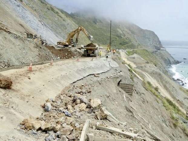
Caltrans employees and contractors used excavators and bulldozers to remove Paul’s Slide debris from California State Highway 1 in 2017. © Kevin Schmidt/USGS
For landslides, the study of friction is still in its early stages, but this paper presents a significant advance. The team found that friction affects faults and landslides in a similar fashion by using measurements of stress from instrumentation at the landslide sites, and tracking how fast they moved.
They then compared this field data with friction experiments conducted in the lab. Specifically, they looked at how friction within the landslides changed with movement. The measurements from the field were found to align with the lab experiments, providing a consistent picture of how friction influences landslide motion.
Finnegan points to California’s iconic Highway 1 as a prime example of how insights from this study can have a positive, practical impact.
“Caltrans is engaged in this constant battle to keep it open,” he said. “The benefit of this model lies in its ability to assist operational decisions on a more informed basis. It doesn’t just isolate data points but contextualizes them, enabling authorities to predict how changes in factors like rainfall can influence ground movement.”
Importance of material properties
A key part of the research focused on different types of rock and how their behavior under stress varies. For instance, clay-rich rocks tend to creep slowly and stably, while quartz-rich rocks are more likely to experience a sudden drop in friction when they start to slide, leading to catastrophic failure. This understanding could eventually allow scientists to predict how a landslide will behave based on the types of rock present in an area.
The researchers used field observations from two sites in Northern California. One is located just east of Fremont, which Finnegan first identified and has monitored for eight years. The other is in Humboldt County, far to the north, where observations were made by different scientists in the eighties. Both sites lie within the “Franciscan Melange,” a rock formation that is prone to slow-moving landslides. This formation is the remnant of an ancient subduction zone, where one tectonic plate slid beneath another, similar to what is happening today in the Cascadia region of Northern California.
According to Saffer, a key insight came when they connected field observations at the two sites with the kinds of data generated in rock-deformation experiments in the lab. They found that by thinking of the landslide itself as a large-scale “experiment,” the slides’ motion encoded clues about the material’s physics.
“It’s basically a giant rheology (rock deformation) experiment,” he said. “And it suggests that if we were to sample rocks in a region and take the reverse approach—by making detailed measurements of the rheology in the laboratory—we could in theory identify places where catastrophic rapid landslides are more likely and places where we expect the land to creep. That’s where we want to take this work next.”
Unlocking tectonic insights
One of the more abstract–but equally important–implications of this study is its relevance to plate tectonics and subduction zones. The rocks involved in the landslides being studied at one point existed at the interface of an ancient subduction zone, a setting that is notorious for producing devastating magnitude-9 earthquakes. These earthquakes are among the most destructive natural disasters on Earth.
Studying slow landslides in these types of rocks could offer valuable insights into the mechanics of slip processes in subduction zones. Due to the difficulty of taking direct measurements in these deep underwater fault environments, landslide research could illuminate how these plate interfaces behave under various conditions. In particular, understanding slip behavior in the fault zones at the seafloor could enhance predictions related to earthquake-triggered tsunamis, helping experts understand how and when these critical seismic events might occur.
“Apart from the practical value of this work, it’s also an example of how crossing disciplinary boundaries provides new insights on old problems,” Finnegan said. “In this case, we show how landslides—where it is relatively easy to make measurements—can provide a window into processes acting deep within faults, where measurements are nearly impossible but physical constraints are crucial for understanding hazards.”
More information:
Noah J. Finnegan et al, Seasonal slow slip in landslides as a window into the frictional rheology of creeping shear zones, Science Advances (2024). DOI: 10.1126/sciadv.adq9399
Provided by
University of California – Santa Cruz
Citation:
Understanding landslides: A new model for predicting motion (2024, October 16)


