Using a new dataset, Rafael Prieto-Curiel of the Complexity Science Hub and colleagues analyzed the coordinates and surface of 183 million buildings in nearly 6,000 cities across all 52 countries in Africa. With their model, they quantify the shape of cities. Thus, they show that if a city’s population doubles, the energy demand associated with commuting triples. These results clearly show how important it will be to plan fast-growing cities in a sustainable way.
“Our model allows us to estimate African cities’ transport requirements and energy needs with a never before seen accuracy,” Prieto-Curiel, researcher at the Complexity Science Hub, says. The research is published in the journal Proceedings of the National Academy of Sciences.
Together with Jorge E. Patino from Universidad EAFIT and Brilé Anderson from OECD, he studied a recently published dataset from Google AI. With this unprecedented data the researchers measured the mean distance between buildings in 6.000 African cities and used it as a proxy for energy demand related to mobility. Africa is an exceptional place for this research. By comparison, there are less than 400 metropolitan areas in the US. In addition, African cities will grow faster than ever before.
“Based on the distance between buildings, we calculated the expected distance and time to travel for every single person within a city,” Prieto-Curiel explains. Their result: double the population means triple the energy costs. After all, more people are traveling longer distances.
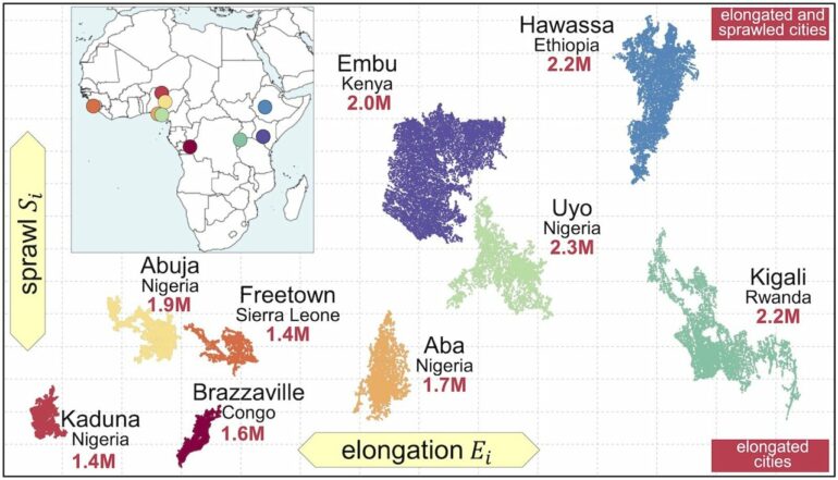
Large cities tend to be round, small cities sausage-shaped
This tripling effect is due in part to urban morphology and how cities grow. “Constructing bigger buildings (area and height) near the city center reduces the commuting distance, as well as the energy consumption of the city and helps preserve green spaces,” Prieto-Curiel explains one of their findings.
The team also learned that big cities tend to be shaped differently than smaller cities. As they grow, larger cities tend to become slightly rounder and more compact. Smaller cities tend to have more of a sausage shape.
Sausage shape increases pollution
Imagine two cities that both have the same number of inhabitants. If one is round and compact, then objects and people are relatively close to each other. If the other one is shaped like a sausage, then some people must spend more time and energy to get from one side to the other. The problem with this is not only time, but also pollution. So a sausage-like city causes more pollution because of its shape.
“Frequently, cities grow on the periphery as more housing is built in areas where the city is growing. This type of urban growth increases commuting distances and makes it more difficult to provide enough services for the new houses, such as sewage and electricity,” Prieto-Curiel explains.
A look into the future of Africa
In many parts of the world extensive urbanization has already taken place. In Africa, the next three decades will bring profound changes, forecasts indicate. Currently, cities like Cairo, Lagos, Luanda, Dar es Salaam, Nairobi and Addis Ababa are home to millions of people, and they are expected to increase their size considerably within the next decades.
“By 2050, Africa will have an additional 950 million people living in cities, up from 574 million people in 2015,” Prieto-Curiel states. More buildings—apartments, schools, hospitals, etc.—will have to be constructed.
Where and how these new buildings are built matters greatly because today’s decisions will be with us for decades to come. And the resulting morphology of cities impacts permanently on a city’s energy needs. “We should plan especially those cities that will grow extremely fast in the next twenty years with special consideration. They must be extremely resilient to many challenges,” Prieto-Curiel emphasizes.
Combining enormous amounts of data
To conduct this study, the research team brought together massive amounts of data: A new dataset of Google AI provided coordinates of every single building in Africa’s cities. In combination with data from Africapolis, the German Aerospace Center and OpenStreetMap the researchers measured the shape of nearly 6,000 cities across Africa.
They then constructed a set of indicators. Indicators like the number of buildings, their constructed surface, the amount of space used by the city center, how elongated or compact a city is—to name just a few. These indicators make all cities comparable for the first time—large and small.
“Until now, we only had satellite images, but it was very difficult to manipulate these photos. Especially in smaller cities, it’s not so easy to identify what a building is,” Prieto-Curiel explains. Google AI’s new open access data set has changed that. Using a machine learning process, it can define the vertices of each building as coordinates. Like a city made of Lego bricks.

New data, new chances
Much of the collective knowledge of urban forms in African cities and future energy needs was based on samples of only a few cities. Advancements like the data used for this study and its findings are critical to the future of cities. Only in this way can we put urbanization on a path of resilience and sustainability in the coming decades.
“Our results show that future energy needs for transport could be incredibly cumbersome if trends continue,” Prieto-Curiel states. Designing compact, dense, and better-connected urban forms will help cities be more sustainable and liveable. Particularly in the case of African cities that will experience rapid growth within the next few decades.
More information:
Rafael Prieto-Curiel et al, Scaling of the morphology of African cities, Proceedings of the National Academy of Sciences (2023). DOI: 10.1073/pnas.2214254120
Provided by
Complexity Science Hub Vienna
Citation:
Measuring 6,000 African cities: Double the population means triple the energy costs (2023, February 27)

