A new enhanced 3D radar image offer a greatly improved view of the interior of the Martian north polar cap, according to a paper led by Planetary Science Institute Senior Scientist Nathaniel Putzig.
Putzig’s team, which included PSI researchers Matthew Perry, Isaac Smith, Aaron Russell and intern Isabella Mueller, produced and analyzed the 3D image using observations obtained with the Shallow Radar (SHARAD) instrument on NASA’s Mars Reconnaissance Orbiter (MRO).
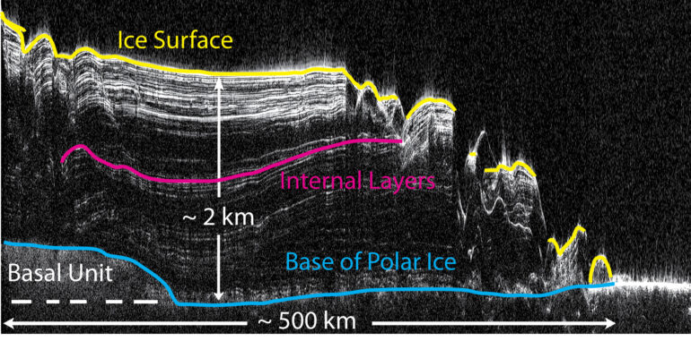
“In creating 3D radargrams, we assemble all the data from many 2D profiles across the region of interest and apply advanced 3D imaging methods to unravel all of the interferences present in the 2D profiles, placing the reflected signals at their points of origin to produce a geometrically corrected 3D image of the subsurface,” said Putzig, lead author of the research that appears in The Planetary Science Journal.
“The new 3D radargram really brings into focus many features that were previously difficult or impossible to map due to incomplete imaging of inherently 3D features with a collection of 2D profiles,” Putzig said. “So far, we have only scratched the surface of understanding what the new data volume is telling us about the history of Martian polar processes and climate, and there is a lot more detailed mapping work to be done.”
SHARAD probes the subsurface—up to 4 kilometers deep—emitting radar waves within a 15- to 25-megahertz frequency band to achieve a desired depth resolution of approximately 15 meters. The returned radar waves, which are captured by the SHARAD antenna, are sensitive to changes in the electrical characteristics of rock, sand, and water ice that may be present in the surface and subsurface.
Changes in the reflection characteristics of the subsurface, caused by layers deposited by geological processes in the ancient history of Mars, are also visible.
“The results of the 3D imaging offer a better understanding of Mars by providing a greatly clarified view of subsurface features, which can be used to inform geologic interpretations of the origins of the polar deposits and their implications for Martian climate history. The details of the subsurface layering geometry can be used to infer the processes involved in the deposition and erosion of the layers over time,” Putzig said.
More information:
Nathaniel E. Putzig et al, New Views of the Internal Structure of Planum Boreum from Enhanced 3D Imaging of Mars Reconnaissance Orbiter Shallow Radar Data, The Planetary Science Journal (2022). DOI: 10.3847/PSJ/ac9d3b

Provided by
Planetary Science Institute
Citation:
3D radargram brings new focus to Mars’ north polar cap (2022, November 28)

