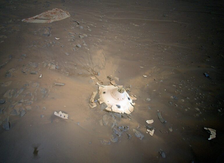
NASA’s Ingenuity Mars Helicopter recently surveyed both the parachute that helped the agency’s Perseverance rover land on Mars and the cone-shaped backshell that protected the rover in deep space and during its fiery descent toward the Martian surface on Feb. 18, 2021. Engineers with the Mars Sample Return program asked whether Ingenuity could provide this perspective. What resulted were 10 aerial color images taken April 19 during Ingenuity’s Flight 26.
“NASA extended Ingenuity flight operations to perform pioneering flights such as this,” said Teddy Tzanetos, Ingenuity’s team lead at NASA’s Jet Propulsion Laboratory in Southern California. “Every time we’re airborne, Ingenuity covers new ground and offers a perspective no previous planetary mission could achieve. Mars Sample Return’s reconnaissance request is a perfect example of the utility of aerial platforms on Mars.”
Entry, descent, and landing on Mars is fast-paced and stressful, not only for the engineers back on Earth, but also for the vehicle enduring the gravitational forces, high temperatures, and other extremes that come with entering Mars’ atmosphere at nearly 12,500 mph (20,000 kph). The parachute and backshell were previously imaged from a distance by the Perseverance rover.
But those collected by the rotorcraft (from an aerial perspective and closer) provide more detail. The images have the potential to help ensure safer landings for future spacecraft such as the Mars Sample Return Lander, which is part of a multimission campaign that would bring Perseverance’s samples of Martian rocks, atmosphere, and sediment back to Earth for detailed analysis.

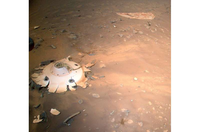
Rover Landing Gear Seen From the Air by Mars Helicopter. © NASA/JPL-Caltech
“Perseverance had the best-documented Mars landing in history, with cameras showing everything from parachute inflation to touchdown,” said JPL’s Ian Clark, former Perseverance systems engineer and now Mars Sample Return ascent phase lead. “But Ingenuity’s images offer a different vantage point. If they either reinforce that our systems worked as we think they worked or provide even one dataset of engineering information we can use for Mars Sample Return planning, it will be amazing. And if not, the pictures are still phenomenal and inspiring.”
In the images of the upright backshell and the debris field that resulted from it impacting the surface at about 78 mph (126 kph), the backshell’s protective coating appears to have remained intact during Mars atmospheric entry. Many of the 80 high-strength suspension lines connecting the backshell to the parachute are visible and also appear intact. Spread out and covered in dust, only about a third of the orange-and-white parachute—at 70.5 feet (21.5 meters) wide, it was the biggest ever deployed on Mars—can be seen, but the canopy shows no signs of damage from the supersonic airflow during inflation. Several weeks of analysis will be needed for a more final verdict.

This image of Perseverance’s backshell (left of center), supersonic parachute (far right), was collected from an altitude of 26 feet (8 meters) by NASA’s Ingenuity Mars Helicopter during its 26th flight on Mars on April 19, 2022. During the Feb. 18, 2021, landing of Perseverance, the parachute and backshell were jettisoned at about 1.3 miles (2.1 km) altitude. The parachute and backshell continued to descend and impacted the ground at approximately 78 mph (126 kph). Engineers working on the Mars Sample Return program requested images be taken from an aerial perspective of the components because they may provide insight into the components’ performance during the rover’s entry, descent, and landing. The image has been cropped and processed from the original version. © NASA/JPL-Caltech
Flight 26 Maneuvers
Ingenuity’s 159-second flight began at 11:37 a.m. local Mars time April 19, on the one-year anniversary of its first flight. Flying 26 feet (8 meters) above ground level, Ingenuity traveled 630 feet (192 meters) to the southeast and took its first picture. The rotorcraft next headed southwest and then northwest, taking images at pre-planned locations along the route. Once it collected 10 images in its flash memory, Ingenuity headed west 246 feet (75 meters) and landed. Total distance covered: 1,181 feet (360 meters). With the completion of Flight 26, the rotorcraft has logged over 49 minutes aloft and traveled 3.9 miles (6.2 kilometers).
“To get the shots we needed, Ingenuity did a lot of maneuvering, but we were confident because there was complicated maneuvering on flights 10, 12, and 13,” said Håvard Grip, chief pilot of Ingenuity at JPL. “Our landing spot set us up nicely to image an area of interest for the Perseverance science team on Flight 27, near ‘Séítah’ ridge.”
The new area of operations in Jezero Crater’s dry river delta marks a dramatic departure from the modest, relatively flat terrain Ingenuity had been flying over since its first flight. Several miles wide, the fan-shaped delta formed where an ancient river spilled into the lake that once filled Jezero Crater. Rising more than 130 feet (40 meters) above the crater floor and filled with jagged cliffs, angled surfaces, projecting boulders, and sand-filled pockets, the delta promises to hold numerous geologic revelations—perhaps even proof that microscopic life existed on Mars billions of years ago.
Upon reaching the delta, Ingenuity’s first orders may be to help determine which of two dry river channels Perseverance should climb to reach the top of the delta. Along with route-planning assistance, data provided by the helicopter will help the Perseverance team assess potential science targets. Ingenuity may even be called upon to image geologic features too far afield for the rover to reach or to scout landing zones and sites on the surface where sample caches could be deposited for the Mars Sample Return program.
Provided by
Jet Propulsion Laboratory
Citation:
Ingenuity Mars Helicopter spots gear that helped Perseverance rover land (2022, April 27)


