As cities continue to grow globally, characterizing the built environment is essential to understanding human populations, projecting energy usage, monitoring urban heat island impacts, preventing environmental degradation, and planning for urban development. Buildings are a key component of the built environment and there is currently a lack of data on building height on a global level.
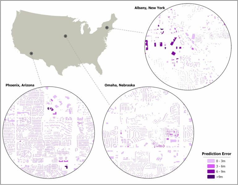
Clinton Stipek with the Department of Energy’s Oak Ridge National Laboratory is using machine learning to provide a more complete picture of building geometries that include building height to within 3 meters of accuracy, a feat difficult to achieve until now.
Previous methods for determining building height required information about more than just the structure itself, such as roads or the number of people inside. Using features of a building and surrounding structures, Stipek and colleagues designed an algorithm to figure out how to estimate height for buildings anywhere in the world.
“We developed an open-source code that uses building morphology features at a building level to predict a height,” Stipek said. “The algorithm can be used anywhere in the world, removing former barriers such as how to define a building or measuring shadows that create false positives.” The team published their results in Scientific Reports.
Stipek’s colleague, Taylor Hauser, became interested in filling in the gap of building height while working on the U.S. Structures project, an ORNL dataset that inventories structures across the nation larger than 450 square feet and is used by the Federal Emergency Management Agency and other U.S. government organizations.
“We had people manually going through this massive dataset to identify incorrect data, such as where building shadows caused the previous machine learning models to miscalculate results,” said Hauser, a geospatial data analyst.
“I began to develop a tool that can generate a significant number of measurements collectively known as building morphologies to describe aspects of a building, particularly in relationship to neighboring buildings.”
By pulling information about surrounding structures, more accurate inferences about the data could lead to higher confidence in the data. Hauser began thinking, if building morphologies can be used to identify incorrectly detected structures from satellite imagery, what else could they do?
Hauser and Stipek worked together to incorporate 65 building morphology features into height calculations. Stipek used a gradient boosting tree algorithm called XGBoost to cluster pieces of information together that work in a tree structure to come to an inference about building height. The results point to what Hauser refers to as a hidden signal to predict the third dimension, height, just by using two-dimensional building morphologies.
The results of Stipek and Hauser’s work are being incorporated into other major projects such as LandScan, an ORNL population mapping program in its 25th year, and Global Building Intelligence, which aims to fully attribute building features including purpose, height, materials, age and roof shape.
Building height, population mapping and other research into understanding where people are in the world is part of ORNL’s national security mission. The lab’s geospatial datasets give policy makers and first responders information to provide services to those impacted by manmade and natural events. Hauser said these different datasets are derived from similar data used in distinct applications.
“We can learn more about city planning, buildings, roads, infrastructure,” Hauser said. “We’re trying to fill in gaps where information doesn’t exist.”
More information:
Clinton Stipek et al, Inferring building height from footprint morphology data, Scientific Reports (2024). DOI: 10.1038/s41598-024-66467-2
Provided by
Oak Ridge National Laboratory
Citation:
Global building height prediction made easy with machine learning (2024, December 11)


