With record-breaking temperatures across the South, smoke from Canadian wildfires across the North, historic flooding in the Northeast and a powerful hurricane in the Southeast, the summer of 2023 has presented a range of threats to the safety of the majority of Americans. The good news, through all of this: Geospatial intelligence has offered valuable insights to help governments and organizations protect communities.
Geospatial intelligence is the collection and integration of data from a network of technologies, including satellites, mobile sensors, ground-control stations and aerial images. The data is used to produce real-time maps and simulations to help identify when, where and to what extent a threat is likely to emerge. Government officials, individuals or both can use this information to make informed decisions.
Disasters sudden and slow
One long-standing contribution of geospatial intelligence is in emergency preparedness and response. For example, the National Hurricane Center actively monitors the location, formation and trajectory of tropical cyclones. Detailed information on the timing, location and strength of a given hurricane helps officials distribute resources and personnel, as well as issue storm warnings and evacuation orders.
Geospatial intelligence also provides valuable guidance for search-and-rescue and recovery efforts following a disaster. For example, in the immediate aftermath of the February 2023 7.8 magnitude earthquake that struck Turkey and Syria, maps and aerial images quickly identified the extent of damage and the populations affected. In addition, they helped first responders locate access points in the transportation network to rescue survivors, set up aid stations and provide emergency supplies.
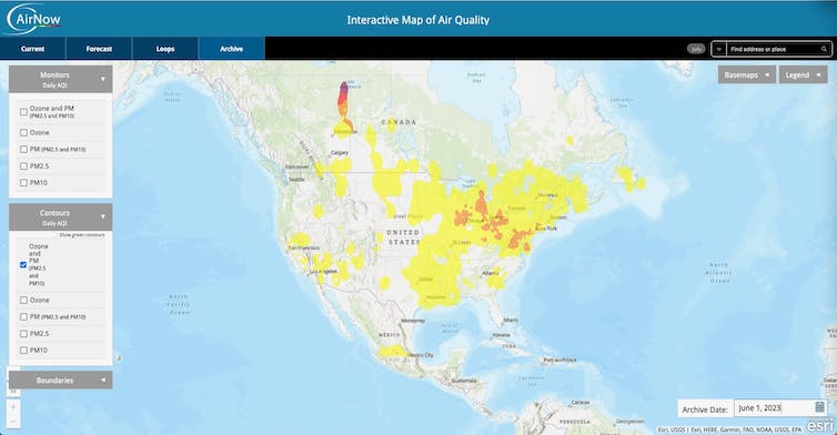
The Environmental Protection Agency publishes air quality maps that are particularly useful when smoke from wildfires spreads across large parts of the U.S.
EPA
Another use of geospatial intelligence is environmental monitoring. A stable environment is essential for human health and security. Monitoring temperature, precipitation, snowpack and polar ice helps scientists and government officials anticipate and prepare for potential disturbances.

For instance, understanding temperature profiles – past, current and forecasted temperatures over an area – provides information on when, where and to what extent that area is likely to be affected by events such as heat waves. Heat waves often result in human suffering, increased energy demands and crop damage. With climate change intensifying extreme weather events, there is likely to be a corresponding increase in threats to human safety and security.
Military and civilian logistics
The Russian-Ukraine war is another area where geospatial intelligence has made contributions. Maxar Technologies, a commercial satellite imagery company, was the first to report the 40-mile-long convoy of Russian ground forces heading…

