Wildfire blowups, fire whirls, towering thunderstorms: When fires get large and hot enough, they can actually create their own weather.
In these extreme fire situations, firefighters’ ordinary methods to directly control the fire don’t work, and wildfires burn out of control. Firefighters have seen many of these risks in the enormous Park Fire burning near Chico, California, and other wildfires in summer 2024.
But how can a fire create weather?
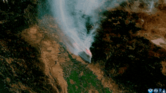
Satellite images shows how the Park Fire near Chico, Calif., created intense pyrocumulonimbus plumes, visible in white, in July 2024. CSU/CIRA and NOAA
I’m an atmospheric scientist who uses data collected by satellites in weather prediction models to better anticipate extreme fire weather phenomena. Satellite data shows fire-produced thunderstorms are much more common than anyone realized just a few years ago. Here’s what’s happening.
The wildfire and weather connections
Imagine a wildland landscape with dry grasses, brush and trees. A spark lands, perhaps from lightning or a tree branch hitting a power line. If the weather is hot, dry and windy, that spark could quickly ignite a wildfire.
When vegetation burns, large amounts of heat are released. This heats the air near the ground, and that air rises like a hot air balloon because hot air is less dense than cool air. Cooler air then rushes in to fill the void left by rising air.
This is how wildfires create their own wind patterns.

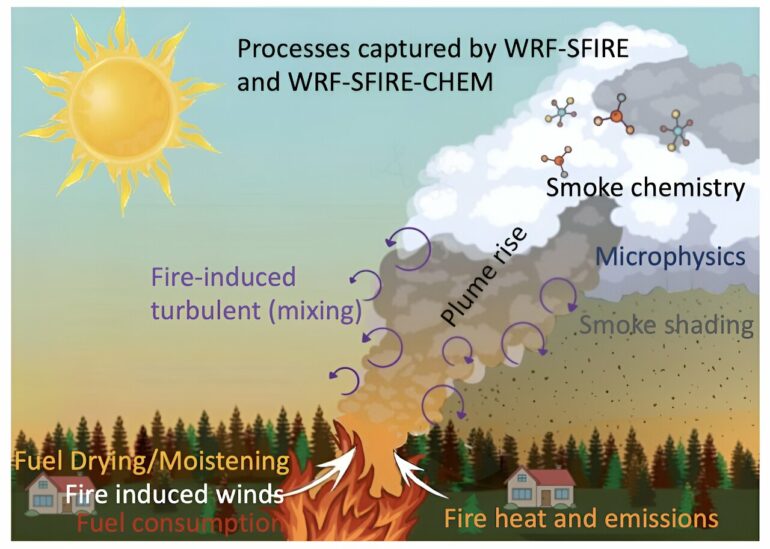
Fires create their own wind patterns and weather as their heat rises. The illustration is based on a coupled fire-atmosphere computer model, WRF-SFIRE-CHEM.
Adam Kochanski/San Jose State University/WIRC
What happens next depends on the stability of the atmosphere. If the temperature cools rapidly with elevation above the ground, then the rising air will always be warmer than its surroundings and it will keep rising. If it rises high enough, the moisture will condense, forming a cloud known as a pyrocumulus or flammagenitus.
If the air keeps rising, at some point the condensed moisture will freeze.
Once a cloud has both liquid and frozen water particles, collisions among these particles can lead to electrical charge separation. If the charge buildup is large enough, an electrical discharge – better known as lightning – will occur to neutralize the charges.

Whether a fire-induced cloud will become a thunderstorm depends on three key ingredients: a source of lift, instability and moisture.
Dry lightning
Wildfire environments typically have limited moisture. When conditions in the lower atmosphere are dry, this can lead to what’s known as dry lightning.
No one living in a wildfire-prone environment wants to see dry lightning. It occurs when a thunderstorm produces lightning, but the precipitation evaporates before reaching the ground. That means there is no rain to help put out any lightning-sparked fires.
Fire…

