
Climate change is making extreme weather events worse, empowering meteorological phenomena such as storms, hurricanes, heat waves, and droughts. Against this backdrop, numerical weather predictions (NWPs), which use complex mathematical models that simulate atmospheric conditions, have become critical to protect people and businesses from these events and other weather-borne disasters.
Unsurprisingly, NWP models need a massive amount of daily data to make accurate predictions. While some of this data comes from satellite images and ground-based stations, a fine atmospheric vertical structure is collected by sensors mounted on weather balloons, released simultaneously every day by meteorological agencies worldwide. These snapshots of temperature, humidity, pressure, and wind at different altitudes provide a detailed, real-time picture of the atmosphere that helps scientists initialize NWP models.
However, maintaining weather balloon observations is a costly and difficult task, which severely limits the spread and coverage of daily measurements. But what if inexpensive drones equipped with sensors could help support NWPs just like weather balloons do?
In a recent study, a research team led by Professor Jun Inoue from the National Institute of Polar Research, Japan, conducted a two-month field campaign in Tsukuba City to investigate whether daily drone-based measurements could be seamlessly made and uploaded to support NWPs. The study was published in the Journal of Geophysical Research: Atmospheres on January 16, 2025.
“We instigated this field campaign to assess the feasibility of obtaining continuous daily measurements during a period of at least one month using uncrewed aircraft systems (UASs) or drones, to distribute the data in a format designated for NWP, and to evaluate data quality compared to that obtained using more conventional meteorological methods,” says Prof. Inoue.
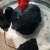
During a two-month period, the research team tested three different types of drones. One of them was a meteorological hexacopter with a suite of built-in meteorological sensors, whereas the other two were commercial quadcopter drones onto which meteorological sensors were mounted.

Researchers conducted daily measurements using drones over two months to gather meteorological data near an urban center in Japan. Their findings highlight the power of drones and similar unmanned aerial systems to support numerical weather predictions cost-effectively. © Prof. Jun Inoue from the National Institute of Polar Research, Japan
Because of flight regulations in urban areas, drones could only ascend to a maximum height of 900 m. Every day during the study period, members of the team would launch these drones at designated times and use a laptop to convert the gathered data into an appropriate format before uploading it.
The researchers compared the data obtained using the drones with routine radiosonde data gathered nearby using weather balloons. Notably, air temperature, humidity, and wind speed measurements from drones did not differ significantly from those of weather balloons, underlining the potential of these devices to support NWP systems in a very cost-effective way. Moreover, data could be converted and uploaded within 30 minutes of making the measurements, which aligns well with current standard operational procedures.
“The results of our field campaign showed that twice-daily UAS profiling is feasible from the viewpoint of data quality and data transfer for the NWP systems,” says Prof. Inoue.
“We also highlight that long-term data validation for each UAS using well-established reference instruments is critical to demonstrate the operational capability of drones for next-generation meteorological observation systems.”
The benefits of using inexpensive drones to make daily meteorological measurements are manifold. They can be easily implemented in sparse meteorological observation areas, such as polar regions, developing countries, and mountain areas, to complement conventional systems.
Since special academic knowledge is not required, trained locals can conduct the necessary tasks and extend the range and density of meteorological data throughout the globe. In turn, this could significantly improve the accuracy of NWP systems, leading to accurate weather forecasting and, most importantly, disaster prevention via early warning.
More information:
Jun Inoue et al, Operational Capability of Drone‐Based Meteorological Profiling in an Urban Area, Journal of Geophysical Research: Atmospheres (2024). DOI: 10.1029/2024JD041927
Provided by
Research Organization of Information and Systems
Citation:
Commercial drones show promise as meteorological tools for numerical weather predictions (2025, January 23)

