How much the ground moves during an earthquake strongly depends on properties of rock and soil just beneath Earth’s surface. Modeling studies suggest that ground shaking is amplified in sedimentary basins, on which populated urban areas are often located. However, imaging near-surface structure around urban areas at high resolution has been challenging.
Yang et al. have developed a new approach of using distributed acoustic sensing (DAS) to construct a high-resolution image of near-surface structure. DAS is an emerging technique that can transform existing fiber-optic cables into seismic arrays. By monitoring changes in how light pulses scatter as they travel through the cable, scientists can calculate small strain changes in the material surrounding the fiber. In addition to recording earthquakes, DAS has proven useful in a variety of applications, such as naming the loudest marching band at the 2020 Rose Parade and uncovering dramatic changes in vehicular traffic during COVID-19 stay-at-home orders.
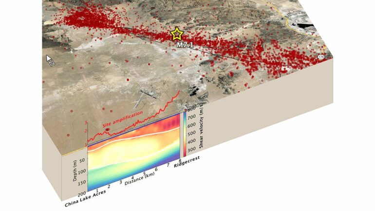
Prior researchers repurposed a 10-kilometer stretch of fiber to detect aftershocks following the magnitude 7.1 Ridgecrest earthquake in California in July 2019. Their DAS array detected about six times as many small aftershocks as conventional sensors did during a 3-month period.
In the new study, the researchers analyzed continuous seismic data produced by traffic. The DAS data allowed the team to develop a near-surface shear velocity model with a subkilometer resolution two orders of magnitude higher than typical models. This model revealed that along the length of the fiber, sites where aftershocks produced more ground motion generally corresponded with where shear velocity was lower.
Such fine-scale seismic hazard mapping could improve urban seismic risk management, especially in cities where fiber-optic networks may already be present, the authors suggest.
More information:
Yan Yang et al, Sub‐Kilometer Correlation Between Near‐Surface Structure and Ground Motion Measured With Distributed Acoustic Sensing, Geophysical Research Letters (2021). DOI: 10.1029/2021GL096503
Provided by
American Geophysical Union
This story is republished courtesy of Eos, hosted by the American Geophysical Union. Read the original story here.
Citation:
Fiber-optic cables can produce high-resolution underground maps (2022, February 15)

