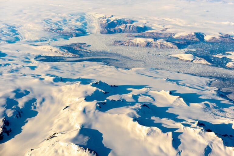
A team of international researchers has shown for the first time how 18 meltwater lakes in Greenland collapse during winter, which causes the edges of the ice to flow faster. The new knowledge is essential for understanding how climate change influences the flow of ice masses in the Arctic.
In the middle of winter in 2018, an almost 50-year-old meltwater lake disappeared from the ice sheet in western Greenland. The lake was covered by snow and ice when it collapsed but stored liquid water inside. The water disappeared into newly formed cracks and drifted down through the approximately 2 km thick layer of ice. The water hit the rock bed under the ice and flowed out from under the ice sheet toward the sea.
This meltwater acted as lubrication between the rock bed and the thick ice on top. As a result, the large mass of ice could slide faster toward the coast, accelerating an unusually large region of inland ice. The drainage of this lake caused several other lakes in the adjacent area to collapse too. In total, the collapsed lakes have released approximately 180 million tons of meltwater that has ended up in the world’s oceans.
This activity is shown by new international research based on satellite data and led by the French Université Grenoble Alpes with contributions from DTU Space at The Technical University of Denmark (DTU). The study has just been published in Geophysical Research Letters.
“The meltwater lakes on the ice sheet form in the summer when the ice on the surface melts. It is well known that these lakes can collapse and drain during summer. But, surprisingly, this takes place in the winter too. This is the first time that it has been shown that these specific lake drainages cause large ice accelerations during winter when temperatures are very low,” says postdoc and researcher Nathan Maier, lead author of the article.
As a researcher at the Université Grenoble Alpes in France, he led the extensive international research collaboration behind the discovery. He is now a researcher at Los Alamos National Laboratory in the U.S.
“In total, the lakes drained in connection with this incident have resulted in 180 million tons of water flowing into the sea. This is roughly equivalent to the contents of 80,000 Olympic swimming pools measuring 50 by 25 by 2 meters,” states Nathan Maier.
The 50-year-old lake, which was the first to drain, was located approximately 160 km inland, high on the ice sheet. The lake consisted of melted water and had a frozen ice lid because of the cold winter temperatures. When it collapsed, and the water flowed underneath the ice toward the coast of western Greenland, it started a cascade of events that caused other lakes to be drained of their water too. Among other things, the pressure from the water that ran under the ice from the 50-year-old lake probably helped to form further cracks in the ice above, making these lakes leak as well.
18 lakes drained in an area about three times the size of greater London
A total of 18 lakes collapsed accelerating a 5,200 square kilometers area of the ice sheet, corresponding to more than three times the size of greater London. The researchers note that it happened across a month in the winter of 2018 when air temperatures were below freezing.
“We have only investigated a limited area, but we have good reason to assume that similar events take place in many more places in Greenland. If this applies to larger parts of the ice sheet, it could be quite large amounts of meltwater that disappear in this way and cause the ice sheet to slide faster towards the sea,” says Jonas Kvist Andersen, a postdoctoral researcher at DTU Space in Denmark and co-author of the article.
The investigated area primarily includes the large Jakobshavn Isbræ, which flows into the sea in western Greenland and is the fastest flowing glacier in the world, as well as a smaller glacier south of it that ends on land.
Unknown if winter drainages will become more prevalent
It seems obvious to conclude that the lakes have started to collapse in winter due to global warming. Especially when an almost 50-year-old lake is suddenly drained in the middle of winter and the meltwater ends up in the sea and contributes to sea level rise. But that is not a given, according to the researchers.
“It is still unknown if drainages like these will become more prevalent in a warmer future and then contribute further to ice sheet mass loss. More research is needed to get a better understanding of the mechanisms, or triggers, that cause the lakes to drain,” says Nathan Maier.
“Right now, our understanding of how surface melting will affect mass loss from Greenland in the future is based entirely on the assumption that melting only affects the speed of the ice flow during summer. Our discovery, that large accelerations in the ice flow caused by stored meltwater that drains during winter, significantly changes how we understand ice sheet hydrology over annual time scales.”

The researchers have arrived at the new results by analyzing large amounts of radar data and satellite optical images.
Winter meltwater drain should be included in new climate models
It is not only the oldest lakes that collapse after existing for decades. There are several types of cycles, according to the scientists. Some lakes form and collapse within a year; for others, it happens every few years.
The collapsed lakes affect the ice sheet, or glacier, melting in Greenland in several ways. The water from the lakes ends up in the sea. The water lubricates the ice sheets from beneath causing them to slide faster towards the coast exposing them to additional melting. In addition, the structure of the enormous ice masses changes. There could be other mechanisms at play as well.
“It is essential to describe what happens when the melting process takes place in winter so that this knowledge can be included in future models for climate change,” states Jonas Kvist Andersen.
Draining lakes and waterflow found with radar data and satellite optical images
The researchers have used Synthetic Aperture Radar (SAR) interferometry based on data from the Sentinel-1 satellites from the European Space Agency (ESA) to map how the 18 lakes on the ice sheet in western Greenland have been drained, and how the water from them has subsequently flowed downwards and out to sea.
Visual and optical photos have been

