Satellite observations have revealed that weak seismic ground shaking can trigger powerful landslide acceleration—even several years after a significant earthquake.
These observations help paint a comprehensive picture of landslide behavior triggered by seismic activity and provide the tools for real-time monitoring to support rapid rescue operations.
Landslides, a natural geological hazard worldwide, cause serious human and economic losses every year. Between 1998 and 2017, landslides affected an estimated 4.8 million people worldwide and cause more than 18,000 deaths, according to estimates from the World Health Organization. Landslides can be triggered by earthquakes, volcanoes, rainfall or human activity and the recent landslide that tore across the Italian island of Ischia is an example of a landslide triggered by rainfall.
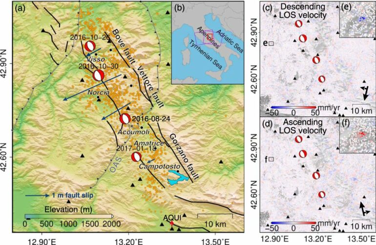
Published in the journal Nature Communications, the study focused on earthquake-accelerated landslides (EALs). These types of landslides are affected by the long-term seismic effects and may maintain accelerated motion for a long time after the earthquake. EALs cause particularly serious human casualties, especially in seismically active areas.
The research was led by Professor Zhenhong Li, presently at Chang’an University (China), and Professor Stefano Utili at Newcastle University. They worked with Professors Giovanni Crosta and Paolo Frattini at the University of Milan-Bicocca, Italy.
The scientists used satellite radar observations to detect and investigate the activation and recovery of EALs in Central Italy. Their work has led to the first ever complete EAL inventory, which has the potential to inform long-term landslide risk assessment in seismically active areas.
Professor Utili, Professor of Geotechnical Engineering at Newcastle University’s School of Engineering, said, “This work is of great significance for long-term landslide risk assessment in areas where we see seismic activity. People tend to think landslides triggered by earthquakes only occur during or immediately after an earthquake, but unfortunately an awful lot of them happen several years after the seismic event in areas previously thought safe so it is not easy to make predictions. This study showcases a cost-effective and efficient methodology based on satellite imagery to identify and assess the risk posed by ground movements becoming catastrophic landslides following an earthquake in the long term. The next steps will be for civil authorities to adopt the methods.”
Co-author Professor Jianbing Peng, Member of Chinese Academy of Sciences (CAS), said, “This study contributes to a comprehensive understanding of the risk of earthquake-induced landslides, including coseismic landslide failures and post-earthquake landslide dynamics, and it is of great significance for the long-term assessment and management of landslide hazards in seismically active areas.”

More information:
Chuang Song et al, Triggering and recovery of earthquake accelerated landslides in Central Italy revealed by satellite radar observations, Nature Communications (2022). DOI: 10.1038/s41467-022-35035-5
Provided by
Newcastle University
Citation:
Landslide risk remains long after an earthquake, according to satellite imagery study (2022, November 30)

