Events in the stratosphere are making long-range weather in Northern Europe easier to forecast, researchers at LMU have discovered.
Weather is a chaotic system and predicting weather conditions several weeks in advance poses considerable challenges. The accuracy of such long-range forecasts remains generally quite low. Accordingly, even moderate improvements can prove valuable for various sectors.
For instance, farmers rely on these forecasts to determine optimal sowing and harvesting times, energy providers use them to anticipate fluctuations in renewable energy production, and public health officials use them to prepare for outbreaks of diseases such as malaria or dengue fever, which are correlated with specific weather conditions.
Researchers at LMU are now investigating a phenomenon that has its origin in the stratosphere, the layer of our atmosphere situated 15 to 50 kilometers above our heads.
“Previous work has shown that during Northern winter the state of the circulation in the polar stratosphere may provide useful information for improved long-range forecasts, especially for weather over the North Atlantic and Eurasia,” explains Thomas Birner, Professor of Theoretical Meteorology at LMU.
In particular, when the polar vortex (a band of strong eastward circumpolar flow at stratospheric levels) strongly weakens or breaks down, the North Atlantic jetstream tends to shift southward, and the likelihood of cold spells over Eurasia increases.
Such vortex breakdowns are relatively rare events that only happen approximately every other winter. But its time has come around again: “One such event is currently unfolding with corresponding expected impacts on Eurasian weather in the coming weeks.”
And now for the weather: Cold, but less chaotic
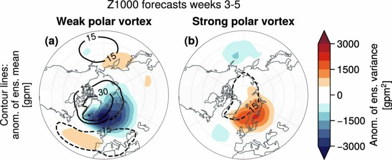
In a study published in Communications Earth & Environment, LMU meteorologists highlight an additional aspect of stratospheric influence on long-range weather forecasts: Weak polar vortex states, such as the one currently prevailing, are typically followed by reduced uncertainty of 3-5 week forecasts over Northern Europe.
The authors found that ensembles of forecasts show a reduced range of possible weather conditions by about 25%. Such ensembles are made up of a large number of individual forecasts, which typically diverge at longer forecasting periods. After weak polar vortex events, there is less spread among these forecasts over Northern Europe, making the weather more predictable.
“We attribute this reduced forecast uncertainty to the southward shift of the North Atlantic jetstream,” says Jonas Spaeth, doctoral student at LMU’s Meteorological Institute and lead author of the new study. The associated southward shift of the tracks of winter storms, which are the main source of forecast uncertainty during this season, causes less storm activity and thereby reduces forecast uncertainty over Northern Europe. Conversely, forecast uncertainty increases over Southern Europe.
“Our study sheds light on meteorological phenomena where uncertainty of weather forecasts several weeks in advance systematically reduces or increases,” says Spaeth. “Furthermore, it underscores how the practical use of long-range forecasts can benefit from a deeper understanding of the remote coupling across different atmospheric regions.”
More information:
Jonas Spaeth et al, Stratospheric impact on subseasonal forecast uncertainty in the Northern extratropics, Communications Earth & Environment (2024). DOI: 10.1038/s43247-024-01292-z
Provided by
Ludwig Maximilian University of Munich
Citation:
Meteorology research: Weak polar vortex makes weather more predictable (2024, March 15)


