Indiana University researchers have uncovered key insights into the dangerous phenomenon of “river avulsion,” offering a way to predict when and where rivers may suddenly and dramatically change course. Published in Nature, this breakthrough study sheds light on a process that has shaped human history through devastating floods and continues to threaten millions of people worldwide.
Led by James “Jake” Gearon, a Ph.D. candidate in the Department of Earth and Atmospheric Sciences (EAS) within the College of Arts and Sciences at Indiana University Bloomington, the research team has outlined for the first time the conditions that create river avulsions.
Co-authors include Harrison Martin (Ph.D. EAS ’23), a post-doctoral fellow now at CalTech, Clarke DeLisle (Ph.D. EAS ’23) now at EVS, Inc, Eric Barefoot, a post-doctoral researcher at IU Bloomington and now a faculty member at UC-Riverside, and Professor Douglas Edmonds, the Malcolm and Sylvia Boyce Chair in Geological Sciences in the Earth and Atmospheric Sciences department.
Using advanced satellite technology, the team mapped how certain landscape features make avulsions more likely. “Measuring topography around a river is difficult and time-consuming because of the dense vegetation,” said Gearon.
“We took advantage of a new satellite that uses lasers to measure topography.” This technology, called lidar, penetrates vegetation to find bare-earth elevations, allowing for accurate topographical measurements.
The study presents a novel framework for predicting when avulsions will occur, a problem humanity has dealt with for millennia. “Avulsions which are possibly the inspirations for ancient flood myths, have created the largest floods in human history, and continue to threaten millions of people today,” explained Edmonds.
“As climate change alters global water cycles and human expansion into flood-prone areas increases, understanding and predicting avulsions has never been more critical.”
What causes river avulsions?
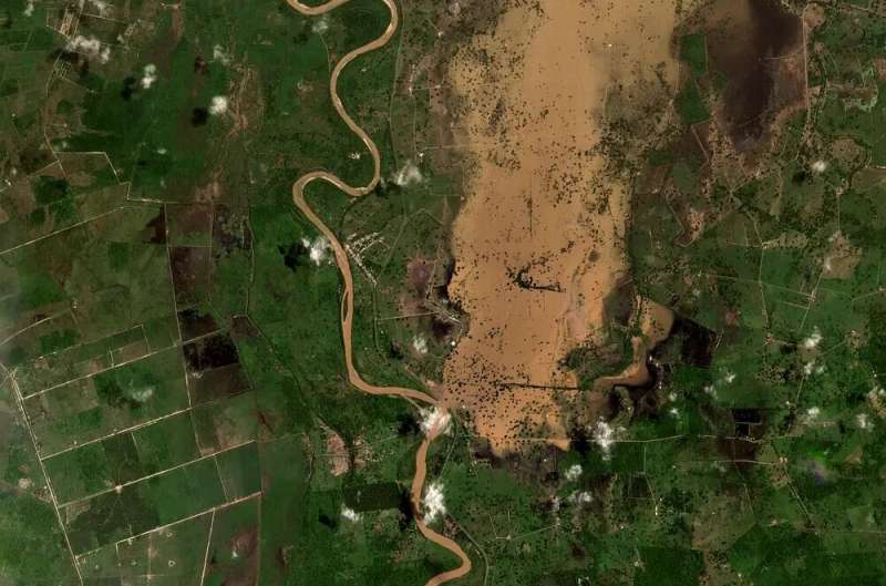
Avulsions occur when a river’s water rises above the surrounding landscape, often due to the buildup of sediment in the riverbed. When this happens, the river may spill over its banks and carve a new path across the floodplain.
This can lead to severe flooding, as the entire river rushes through areas not typically designed to handle such volume. For example, the 2008 avulsion of the Kosi River in Northern India directly affected more than 30 million residents, killed hundreds of people, and caused more than $1 billion dollars in damage.
Traditionally, scientists believed avulsions happened due to two main factors: either the riverbed became elevated above the floodplain, or the land on either side of the river offered a steeper, more appealing path for the water to follow.
“We can now actually test these two 80-year-old ideas with the topography data we have collected from space,” said Edmonds, “and we were surprised to find that both factors work together and play different roles depending on the river’s location.”

Example of an ongoing river avulsion on the Zulia River, Venezuela that began in 2022. © Indiana University
Predicting avulsion hazards—a new way to map flood risks
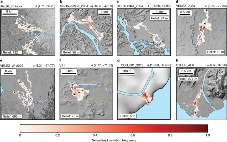
Researchers analyzed data from 174 river avulsions around the world, using satellite imagery to track river movements over the past several decades. The study authors reveal that avulsions are much more common near mountain ranges and coastal areas than in the middle sections of rivers.
They discovered that 74% of these avulsions occurred near mountain fronts or coastlines, areas where sediment tends to build up quickly.
Further, using topographic data, the researchers developed a new model to map what they term “avulsion corridors”—paths that rivers might take if they break from their current course. This tool could help governments and planners identify areas at high risk for sudden flooding, especially in regions with limited flood management resources.
The study also highlights the importance of considering avulsions in flood hazard assessments, something that current flood models don’t usually account for.
“Traditional flood models focus on rising water levels from heavy rains, but avulsions can occur without warning, even in areas where rainfall isn’t a major concern. This makes them particularly dangerous and difficult to predict, much like earthquakes” said Gearon.
Implications for the Global South
The findings could be especially valuable in the Global South—less developed parts of Africa, Latin America, and Asia—where avulsions are more frequent and often more deadly.
In many of these regions, a combination of geological factors and infrastructure challenges makes communities more vulnerable to sudden river changes. The 2010 avulsion-related flooding on the Indus River in Pakistan, for example, affected more than 20 million people.
The new model, which relies on minimal data, could help countries prepare for avulsion-related disasters, potentially saving lives and reducing economic damage.
By offering scientists, policy makers, and practitioners a new way to think about and plan for flood risks—and as climate change continues to reshape weather patterns and increase flood hazards worldwide—the study provides essential tools for understanding and mitigating the dangers posed by river avulsions.
More information:
James H. Gearon et al, Rules of river avulsion change downstream, Nature (2024). DOI: 10.1038/s41586-024-07964-2
Provided by
Indiana University
Citation:
Scientists can now predict catastrophic river shifts that threaten millions worldwide (2024, September 19)


