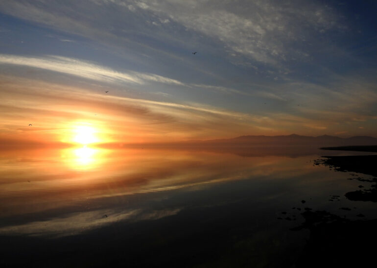
Today, the Salton Sea is an eerie place. Its mirror-like surface belies the toxic stew within. Fish skeletons line its shores and the ruins of a once thriving vacation playground is a reminder of better days. But long before agricultural runoff spoiled the Salton Sea, the lakebed it now occupies was home to a much larger body of water known as Lake Cahuilla. The lake was six times the area of the Salton Sea and once covered much of Mexicali, Imperial and Coachella valleys.
“It was a freshwater lake that was about 100 meters deep in its deepest part,” said San Diego State University emeritus professor of geology Tom Rockwell. “It extended from up near Palm Springs southward into Mexico, so it was a very extensive lake.”
Lake Cahuilla has gone through many cycles of filling and drying out over thousands of years. A new study by Rockwell and his colleagues used radiocarbon dating to determine the timing of the last seven periods of filling. The research sheds light on both the history of human occupation in the area and its seismic past.
Wet and dry periods
Lake Cahuilla got its water from the Colorado River. Once a mighty waterway before it was siphoned off for agriculture and urbanization, the Colorado normally flowed south into the Gulf of California. But periodically, it switched course and began to drain northwest into the Salton Trough, refilling Lake Cahuilla. When full, the water level in the lake could rise to 13 meters above sea level.
“It has this tendency to flip-flop back and forth,” said Rockwell. “But when the Colorado drains to the Gulf of California, Lake Cahuilla would just dry up over a period of 50, 60, or 70 years.”
Sediments from these repeated filling events resulted in fertile soils in the Imperial Valley. An irrigation canal was created around 1900 to bring water from the Colorado River to the Valley for farming, but in 1905, springtime flooding ruptured the canal and gushed toward the Salton Trough, partially refilling the lake to form the Salton Sea. Once the breach was repaired, the water level remained well below that of Lake Cahuilla’s previous incarnations.
To reconstruct its early hydrologic history, Rockwell’s team sampled charcoal, wood, seeds and other organic matter from nearly a dozen in the former lake’s basin. The charcoal samples likely came from cooking fires once used by Indigenous people who inhabited the region.
Historical accounts told of the Colorado River flowing toward the Gulf of California rather than the Salton Trough in 1706, indicating that the lakebed was dry at that time. Based on radiocarbon dating of drowned stumps, Rockwell’s team determined that the last lake to form before the advent of the Salton Sea reached its highest point around 1731.
“But it had to have started drying up by 1732 or 33,” Rockwell said.
Based on an approximate rate of evaporation, that would have made it possible to completely dry out by the time Juan Bautista de Anza’s expedition passed through the area in 1774 and reported that the lakebed had no water in it.
The radiocarbon analysis placed six earlier lake fills between 1618–1636, 1486–1503, 1118–1241, 1007–1070, 930–966, and also 5–612 BCE, with periods of desiccation in between.
Indigenous presence
Rockwell says dating the lakes will help archaeologists understand when the shorelines of Lake Cahuilla were occupied by humans. The lake was an important food source for Indigenous people during both wet and dry periods.
“There were thriving communities of Cahuilla and Kumeyaay hunter gatherers in the area,” said professor of anthropology Todd Braje, who collaborated with Rockwell on an earlier study of human activity around the lake. “It was a magnet for fishing, for gathering plant resources, for people hunting seasonally in this area.”
When the lake was full, Native Americans would set out fish traps. “Fish would swim into these traps and they would harvest them,” said Rockwell. Remnants of the traps still exist today throughout the lakebed.
During dry periods, Indigenous people made use of the fertile sedimentary soils left by previous inundations.
“When the lake was gone, they would farm portions of the lake bottom,” said Rockwell.
Earthquake history
As a geologist, Rockwell is interested in the earthquake history of the San Andreas Fault and several smaller faults that cut through the Salton Trough.
“Once the lakes are dated precisely, I can now sequence all the earthquakes for the last 1100 years for the southern San Andreas system,” said Rockwell.
The weight of the water in the lake and an increase in pore pressure puts stress on the earth’s crust and can trigger earthquakes.
“Most of the last large earthquakes on the southern San Andreas and several on the Imperial Fault occurred when the lake was full,” said Rockwell.
He says the analysis has shifted the estimated date of the most recent major earthquake on the southern San Andreas fault from 1680 to around 1720 or 30, which corresponds with the last filling of the lake.
“That means the time since the last earthquake is about 300 years right now,” said Rockwell. “That’s important because the average time between large San Andreas earthquakes there is less than 200 years, which we think is because there’s been no lake for a few hundred years. And eventually it will break. The question is how much has the lack of water delayed the next Southern San Andreas earthquake?”
Braje says the radiocarbon dating Rockwell and his team undertook represents a massive effort to study a place that doesn’t get much attention from researchers.
“This is a really important story about environmental change and the relationship between humans and these environments over a really long time.”
The research is published in the journal Quaternary Science Reviews.
More information:
Thomas K. Rockwell et al, The late Holocene history of Lake Cahuilla: Two thousand years of repeated fillings within the Salton Trough, Imperial Valley, California, Quaternary Science Reviews (2022). DOI: 10.1016/j.quascirev.2022.107456
Anjali Phukan et al, Shorelines in the Desert: Mapping Fish Trap Features along the Southwest Coast of Ancient Lake Cahuilla, California, Advances in Archaeological Practice (2019). DOI: 10.1017/aap.2019.31
Provided by
San Diego State University
Citation:
The history of Lake Cahuilla before the Salton Sea (2022, May 31)


