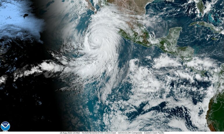
Hurricane Hilary headed for Mexico’s Baja peninsula as a powerful Category 4 storm on Aug. 18, 2023, and was forecast to speed into Southern California at or near tropical storm strength as early as Aug. 20. For the first time ever, the National Hurricane Center issued a tropical storm warning for large parts of Southern California.
Hurricane scientist Nick Grondin explains how Hurricane Hilary, with help from El Niño and a heat dome over much of the country, could bring dangerous flash flooding, wind damage and mudslides to the U.S. Southwest.
How rare are tropical storms in the Southwest?
California has only had one confirmed tropical storm landfall. It was in September 1939 and called the Long Beach Tropical Storm. It caused about US$2 million dollars in damage in the Los Angeles area – that would be about $44 million today. A hurricane in 1858 came close but didn’t make landfall, though its winds did significant damage to San Diego.
What the Southwest does see fairly regularly are the remnants of tropical cyclones, storms that continue on after a tropical cyclone loses its surface circulation. These remnant storms are more common in the region than people might think.
Just last year, Hurricane Kay took a similar track to the one Hurricane Hilary is on and brought significant rainfall to Southern California and Arizona. Famously, Hurricane Nora in 1997 made landfall in Mexico’s Baja California and kept moving north, bringing tropical storm-force winds to California and widespread flooding that caused hundreds of millions of dollars in damage, particularly to fruit trees and agriculture.
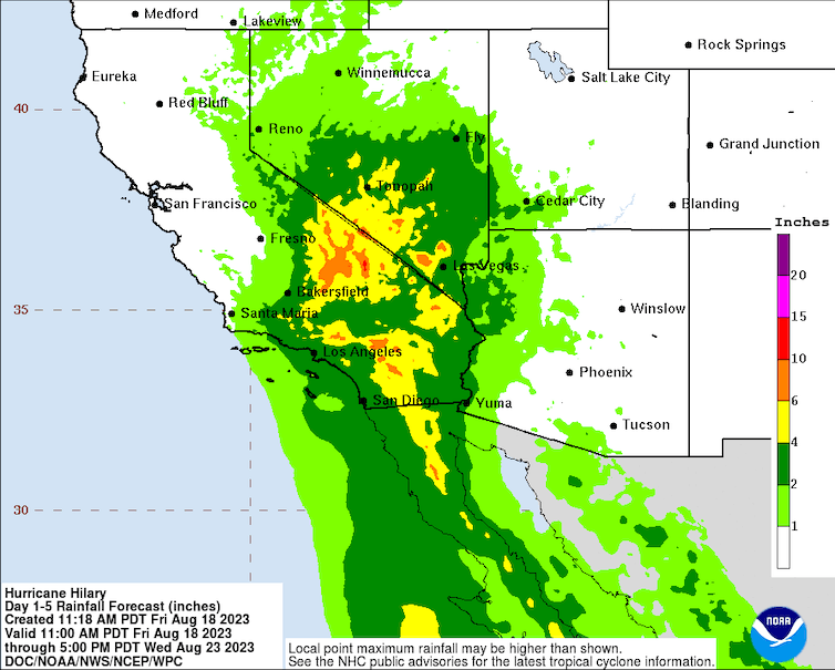
The National Hurricane Center’s five-day rainfall forecast, issued Aug. 18, 2023, shows rainfall totals that are well above what some areas typically receive in a year.
National Hurricane Center
A study led by atmospheric scientist Elizabeth Ritchie in 2011 found that, on average, about 3.1 remnant systems from tropical cyclones affected the U.S. Southwest each year from 1992 to 2005. That’s a short record, but it gives you an idea of the frequency.
Typically, the remnants of tropical cyclones don’t go beyond California, Nevada and Arizona, though it wouldn’t be unprecedented. In this case, forecasters expect the effects to extend far north. The National Hurricane Center on Aug. 18 projected at least a moderate risk of flooding across large parts of Southern California, southern Nevada and far-western Arizona, and a high risk of flooding for regions east of San Diego.

What’s making this storm so unusual?
One influence is the El Niño climate pattern this year, which is showing signs of strengthening in the Pacific. Another, which might be less intuitive, is the heat dome over much of the U.S.
During El Niño, the tropical Pacific is warmer than normal, and both the eastern and central Pacific tend to be more active with storms, as we saw in 2015 and 1997. Generally, hurricanes need at…

