Archaeologists from University College Dublin, working with colleagues from Serbia and Slovenia, have uncovered a previously unknown network of massive sites in the heart of Europe that could explain the emergence of the continent’s Bronze Age megaforts—the largest prehistoric constructions seen prior to the Iron Age.
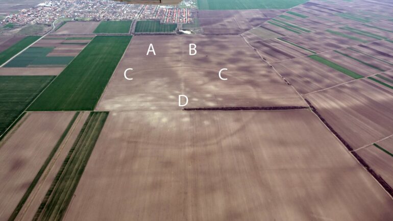
Using satellite images and aerial photography to stitch together the prehistoric landscape of the south Carpathian Basin in Central Europe, the team discovered more than 100 sites belonging to a complex society.
Their commonplace use of defensible enclosures was a precursor and likely influence behind the famous hillforts of Europe, built to protect communities later in the Bronze Age.
“Some of the largest sites, we call these mega-forts, have been known for a few years now, such as Gradište Iđoš, Csanádpalota, Sântana or the mind-blowing Corneşti Iarcuri enclosed by 33km of ditches and eclipsing in size the contemporary citadels and fortifications of the Hittites, Mycenaeans or Egyptians,” said lead author Associate Professor Barry Molloy, UCD School of Archaeology.
“What is new, however, is finding that these massive sites did not stand alone, they were part of a dense network of closely related and codependent communities. At their peak, the people living within this lower Pannonian network of sites must have numbered into the tens of thousands.”
The Carpathian Basin extends across parts of central and southeast Europe, with the vast Pannonian Plain lying at its center, with the River Danube cutting through it.
Detailed in a paper published in the journal PLOS ONE, the new research discovered more than 100 sites in this region located in the hinterlands of the Tisza river, leading to these previously unknown communities to be collectively called the Tisza Site Group (TSG).
Almost all TSG sites lay within 5 km of one another and are aligned along a river corridor formed by the Tisza and the river Danube, suggesting that the network was one of a cooperative community spread across many different locations.
This new research indicates that the TSG were an important center of innovation in prehistoric Europe and formed a major network hub for the region when the Mycenaeans, Hittites and New Kingdom Egypt were at their height around 1500–1200 BC.
This discovery provides new insights into European connections in the second millennium BC, commonly seen as a major prehistoric turning point. It appears the advanced military and earthwork technologies of the society spread across Europe after their collapse in 1200 BC. The importance and influence of these groups help explain similarities in material culture and iconography across Europe in the later second millennium BC, said Molloy.
“Our understanding of how their society worked challenges many aspects of European prehistory. It would be extremely unlikely for each of these 100+ sites to have been individual chiefdoms competing with each other.
“Uniquely for prehistoric Europe, we are able to do more than identify the location of a few sites using satellite imagery but have been able to define an entire settled landscape, complete with maps of the size and layout of sites, even down to the locations of people’s homes within them. This really gives an unprecedented view of how these Bronze Age people lived with each other and their many neighbors,” said Molloy.
“However, this was no peaceful time of plenty. Major innovations in warfare and organized violence took place at this time. The scale of this society indicates it was relevant and powerful on a European stage and between force of arms and major defensible features at settlements, they were well equipped to defend their gains.”
Molloy said that popular perception that archaeology is only based around trowels and brushes, surgically cutting through soil by the millimeter is as close to reality as Indiana Jones.
“We employ a barrage of cutting-edge technologies and in this paper, we relied heavily on imagery from space to discover a previously unknown network of massive sites in the heart of continental Europe—the Carpathian Basin.
“We tested the findings from satellite images on the ground using survey, excavation, and geophysical prospection. The vast majority of sites were established between 1600 and 1450 BC and virtually all of them came crashing down around 1200 BC, being abandoned en masse.
“1200 BC was a striking turning point in Old World prehistory, with kingdoms, empires, cities, and whole societies collapsing within a few decades throughout a vast area of southwest Asia, north Africa, and southern Europe.
“It is fascinating to discover these new polities and to see how they were related to well-known influential societies yet sobering to see how they ultimately suffered a similar fate in a wave of crises that struck this wider region” said Molloy.
More information:
Barry Molloy et al, Resilience, innovation and collapse of settlement networks in later Bronze Age Europe: New survey data from the southern Carpathian Basin, PLOS ONE (2023). DOI: 10.1371/journal.pone.0288750
Provided by
University College Dublin
Citation:
Archaeologists uncover Europe’s hidden Bronze Age megastructures (2023, November 20)

