Archaeologists have used high-resolution LiDAR equipment mounted on a drone to investigate a section of the battlefield of the Battle of the Bulge (December 1944 to January 1945), revealing almost 1,000 previously unknown features.
The battle was Germany’s final major offensive on the Western Front, and one of the largest and bloodiest of the Second World War.
However, dense forest cover in the area meant that most traces of the battle in the landscape remained hidden. Aerial photographs cannot see through the tree canopy, and the battlefield is too large to survey entirely on-foot.
“Although this is a ‘high-profile’ battlefield, studied intensively by military historians and the subject of significant attention in museums and the popular media, little has been published on its material remains,” says lead author of the research, Dr. Birger Stichelbaut from Ghent University.
To tackle this gap in our knowledge, Dr. Stichelbaut and a team of researchers from Ghent University, the University of Toronto and Argus Vision carried out a drone-mounted LiDAR survey of the battlefield. Their results are published in the journal Antiquity.
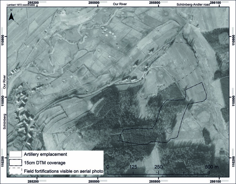
LiDAR uses laser imaging to form maps of landscapes by “seeing through” forest cover. In this case, the team used SLAM-LiDAR to create high-resolution maps of the study area and then extrapolated them over the wider battlefield to better understand features visible on a low-resolution national LiDAR dataset.
. DOI: 10.15184/aqy.2023.95")
© Antiquity (2023). DOI: 10.15184/aqy.2023.95
“This allowed for traces of the battle to be observed on a scale not known until now,” says Dr. Stichelbaut.
This is the first application of SLAM in conflict archaeology. The method uncovered a wide variety of features such as dugouts, bomb craters and even artillery emplacements. This demonstrates how SLAM can make large-scale landscape mapping of military heritage sites more possible than ever before.
By visiting the newly identified features on the ground, the researchers were then able to tie them to specific events. For example, through the discovery of German objects at American artillery embankments, the team determined that German forces made use of abandoned American fortifications.
Importantly, this provides an understanding of the extent and significance of the battle for the first time, revealing the three phases of the battle in the landscape itself.
. DOI: 10.15184/aqy.2023.95")

© Antiquity (2023). DOI: 10.15184/aqy.2023.95
The technique can be applied to other wooded areas in Europe, so could have dramatic implications for our understanding of Second World War battlefields.
It also opens new possibilities for the protection of valuable heritage sites.
“Our case study makes clear that there is potential for enhancing public awareness of and access to some sites in the Ardennes,” state the authors. “The recognition and designation of these traces of war as heritage sites could help guarantee their long-term protection from destructive practices, including the mechanized clearfelling of forest.”
More information:
Birger Stichelbaut et al, LiDAR and conflict archaeology: the Battle of the Bulge (1944–1945), Antiquity (2023). DOI: 10.15184/aqy.2023.95
Citation:
Drones reveal the secrets of one of World War II’s bloodiest battles (2023, August 16)

