It’s easier than ever to view maps of any place you’d like to go—by car, that is. By foot is another matter. Most cities and towns in the U.S. do not have sidewalk maps, and pedestrians are usually left to fend for themselves: Can you walk from your hotel to the restaurants on the other side of the highway? Is there a shortcut from downtown to the sports arena? And how do you get to that bus stop, anyway?
Now MIT researchers, along with colleagues from multiple other universities, have developed an open-source tool that uses aerial imagery and image-recognition to create complete maps of sidewalks and crosswalks. The tool can help planners, policymakers, and urbanists who want to expand pedestrian infrastructure.
“In the urban planning and urban policy fields, this is a huge gap,” says Andres Sevtsuk, an associate professor at MIT and a co-author of a new paper detailing the tool’s capabilities. “Most U.S. city governments know very little about their sidewalk networks. There is no data on it. The private sector hasn’t taken on the task of mapping it. It seemed like a really important technology to develop, especially in an open-source way that can be used by other places.”
The tool, called TILE2NET, has been developed using a few U.S. areas as initial sources of data, but it can be refined and adapted for use anywhere.
“We thought we needed a method that can be scalable and used in different cities,” says Maryam Hosseini, a postdoc in MIT’s City Form Lab in the Department of Urban Studies and Planning (DUSP), whose research has focused extensively on the development of the tool.
The paper, “Mapping the Walk: A Scalable Computer Vision Approach for Generating Sidewalk Network Datasets from Aerial Imagery,” appears online in the journal Computers, Environment and Urban Systems.
Significant research for the project was conducted at NYU when Hosseini was a student there, working with Silva as a co-advisor.
There are multiple ways to attempt to map sidewalks and other pedestrian pathways in cities and towns. Planners could make maps manually, which is accurate but time-consuming; or they could use roads and make assumptions about the extent of sidewalks, which would reduce accuracy; or they could try tracking pedestrians, which probably would be limited in showing the full reach of walking networks.
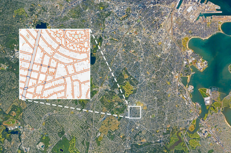
Instead, the research team used computerized image-recognition techniques to build a tool that will visually recognize sidewalks, crosswalks, and footpaths. To do that, the researchers first used 20,000 aerial images from Boston, Cambridge, New York City, and Washington—places where comprehensive pedestrian maps already existed. By training the image-recognition model on such clearly defined objects and using portions of those cities as a starting point, they were able to see how well TILE2NET would work elsewhere in those cities.
Ultimately the tool worked well, recognizing 90% or more of all sidewalks and crosswalks in Boston and Cambridge, for instance. Having been trained visually on those cities, the tool can be applied to other metro areas; people elsewhere can now plug their aerial imagery into TILE2NET as well.
“We wanted to make it easier for cities in different parts of the world to do such a thing without needing to do the heavy lifting of training [the tool],” says Hosseini. “Collaboratively we will make it better and better, hopefully, as we go along.”
The need for such a tool is vast, emphasizes Sevtsuk, whose research centers on pedestrian and nonmotorized movement in cities, and who has developed multiple kinds of pedestrian-mapping tools in his career. Most cities have wildly incomplete networks of sidewalks and paths for pedestrians, he notes. And yet it is hard to expand those networks efficiently without mapping them.
“Imagine that we had the same gaps in car networks that pedestrians have in their networks,” Sevtsuk says. “You would drive to an intersection and then the road just ends. Or you can’t take a right turn since there is no road. That’s what [pedestrians] are constantly up against, and we don’t realize how important continuity is for [pedestrian] networks.”
In the still larger picture, Sevtsuk observes, the continuation of climate change means that cities will have to expand their infrastructure for pedestrians and cyclists, among other measures; transportation remains a huge source of carbon dioxide emissions.

“When cities talk about cutting carbon emissions, there’s no other way to make a big dent than to address transportation,” Sevtsuk says. “The whole world of urban data for public transit and pedestrians and bicycles is really far behind [vehicle data] in quality. Analyzing how cities can be operational without a car requires this kind of data.”
On the bright side, Sevtsuk suggests, adding pedestrian and bike infrastructure “is being done more aggressively than in many decades in the past. In the 20th century, it was the other way around, we would take away sidewalks to make space for vehicular roads. We’re now seeing the opposite trend. To make best use of pedestrian infrastructure, it’s important that cities have the network data about it. Now you can truly tell how somebody can get to a bus stop.”
More information:
Maryam Hosseini et al, Mapping the walk: A scalable computer vision approach for generating sidewalk network datasets from aerial imagery, Computers, Environment and Urban Systems (2023). DOI: 10.1016/j.compenvurbsys.2023.101950
Provided by
Massachusetts Institute of Technology
This story is republished courtesy of MIT News (web.mit.edu/newsoffice/), a popular site that covers news about MIT research, innovation and teaching.
Citation:
First open-source tool to let planners map pedestrian networks (2023, March 15)

