The monstrous Dorian has become the strongest hurricane to hit the Northwestern Bahamas, with sustained winds reaching 180 mph (285 km/h), the National Hurricane Center (NHC) reported today (Sept. 1) at 11 a.m. ET.
At that time, the eye of the Category 5 storm was churning about 20 miles (30 kilometers) east-northeast of Great Abaco Island and 205 miles (330 km) east of West Palm Beach, Florida. The storm is moving toward the west at about 7 mph (11 km/h). That slow speed means Dorian will have plenty of time to dump huge amounts of rain along its path.
The NHC forecasts the core of Dorian will continue to move over Great Abaco and then near or over Grand Bahama Island later tonight and Monday (Sept. 2). Late Monday through Tuesday night, the extremely dangerous storm is expected to move closer to the east coast of Florida.
“Catastrophic hurricane conditions are occurring in the Abacos Islands and will spread across Grand Bahama Island later today and tonight,” the NHC said in the 11 a.m. update.
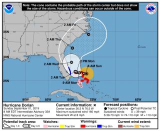
Here’s the potential path of Category 5 Hurricane Dorian as of Sept. 1, 2019.
(Image NHC)

Dorian is truly a giant, continuing to grow larger in size, NHC forecasters say. Currently, hurricane-force winds extend 45 miles (75 km) from the hurricane’s center.
Where (and if) Dorian will make landfall in the U.S. seems to be an open question, with forecasts showing various possibilities from Florida north to the Carolinas, according to a CNN report.
If Dorian does make landfall as a Category 5 storm, that would make the storm a rare one. In 2017, two storms did so — Maria, which slammed into Dominica; and Irma, which hit Cuba, Barbuda, Saint Martin and the British Virgin…

