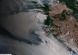
Disturbing new satellite imagery shows the vast scope of the wildfires burning in Washington, Oregon and California. Dozens of fires have turned skies orange, rained ash on cities and towns, destroyed several million acres of land and killed at least seven people. The Sept. 8 imagery comes courtesy of the Cooperative Institute for Research in the Atmosphere (CIRA) at Colorado State University. The GIF, posted on Twitter by meteorologist Dakota Smith, combines two types of imagery from the GOES-West Satellite: GeoColor, which shows the smoke clouds and the topography below; and Fire Temperature imagery, which uses infrared cameras to pinpoint the fires themselves.
Smoke pours and swirls from the fires. Updated imagery from Wednesday (Sept. 9) shows the blanket of smoke still enveloping the coast from the northern end of Oregon down. This smoke turned skies in the Bay Area and elsewhere along the coast an eerie, apocalyptic orange.
The severe fires this year are a result of heat and dry weather, and are exacerbated by climate change, according to climate researchers.
Thousands of people have evacuated their homes due to the fires, and hundreds have had to be rescued from approaching flames. California’s Creek Fire, which started on Sept. 4 in the Sierra National Forest and which spawned a towering pyrocumulonimubus cloud more than 8.5 miles (14,000 meters) tall, required California’s Air National Guard to rescue 200 people trapped by the fires.
At least 2.5 million acres (1 million hectares) have been destroyed in California alone, according to CNBC. Oregon Gov. Kate Brown told reporters on Wednesday that the towns of Detroit, Blue River, Vida, Phoenix and Talent have been “substantially destroyed.” Combined, those communities are home to approximately 13,350 people.
Brown said that about 300,000 acres (about 121,000 hectares) in Oregon were burning, or about 470 square miles (1,217 square kilometers). According to CalFire, California has lost 3.1 million acres, or about 4,844 square miles (12,546 square km), to wildfires since the beginning of this year. There are currently 29 major fires burning in the Golden State. In Washington, where 10 fires are currently raging — one that killed a 1-year-old boy as his family fled their home in Cold Springs — more than 32,460 acres (50.7 square miles or 131 square km) have burned since the beginning of the year, the vast majority in July and August.

Originally published in Live Science.

